This helmet consists of a visor to protect the face and a shell covering the rest of the head. It is made entirely of iron coated with silver except for the crown area, which was originally covered with fabric; the material has disappeared but the imprint of its fibers is visible in the rust.
This luxury object, with its polished silver mask and finely sculpted diadem and rear peak, was probably used for parades. However, it was also made to be worn in battle, since there is a hinge above the forehead that attaches the visor to the helmet.
As well, holes have been made under the eye openings so that the wearer could look down to see where he was going. The helmet must have belonged either to an Arab king of Emesa, or at least someone close to the king, since it was discovered in the city's royal necropolis.
The Roman historian Arrian relates that the auxiliary cavalry of the Roman army took part in tournaments in which the adversaries wore masked helmets.
This helmet was probably made in the workshop of Antioch, which were famous for their precious metal products. It is very likely that the silversmith modeled the mask's features to resemble those of the person who would wear it.
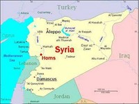
The city of Emesa (present-day Homs) was very important in the Roman period, since it controlled a network of trade routes. The local dynasty that ruled the city and its territory no doubt profited greatly from this economic prosperity.
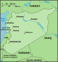
City in Syria with 650,000 inhabitants (2003 estimate), capital of the Homs province, near the Orontes River. Homs has a strategic position, facing the only natural gateway between the Mediterranean coast and the densely populated interior (with access to Aleppo to the north and Damascus to the south). The main product of Homs is silk. Other important products include jewelry, belts and cloaks. Industries include an oil refinery, production of fertilizers, vegetable oil, refined sugar. The surrounding area produces wheat, corn, millet, cotton, fruits and vegetables, for which Homs is the centre of trade. Homs has a university that opened in 1979, a very important military academy, as well as an agricultural research station.
Emesát 638-ban érte el az arab hódítás. Az arabokat 1076-ban a szeldzsukok követték. 1146-tól 1178-ig a város Aleppó, majd 1183-ig – hosszú századok után ismét – Hamath fennhatósága alatt állt. A hányatott sorsú emesaiaknak ezután 1263-ig az Ajjúbidák, majd az egyiptomi mamelukok dirigáltak. De a fejük felett átviharzó küzdelmek ekkor sem csitultak el. 1516-ban az oszmánok rendezkedtek be a településen, akiknek hivatalnokai jól érezték itt magukat egészen 1918-ig. Ekkor a törökök a városból kitakarodtak, és a francia gyarmatosító törekvések kudarcaként Emesa város 1946-ban Szíria fennhatósága alá került.
Kr. e. 719-ig valószínűleg Hamath városhoz tartozott. Ezután 612-ig asszír, utána méd, végül 539-ig babiloni érdekövezet volt. A perzsa hódítást makedón uralom követte a 332–323 közötti időben. Kr. e. 301-ig a várost az Antigonidák, 198-ig a Ptolemaidák uralták, őket követték Kr. e. 68-ig a Szeleukidák, majd Róma és Bizánc.
Emesa város uralkodócsaládja ekkoriban a Sampsigeramida nemzetség volt, e királyok főpapként is tevékenykedtek: I. Šamašgeram (Sampsigeramus) Kr. e. 69–43, Imblichus Kr. e. 64–31, Alexander Kr. e. 31–29, II. Imblichus Kr. e. 20–11, II. Šamašgeram Kr. e. 11–Kr. u. 42, Aziz (Asisus) Kr. u. 42–54, Julius Sohemus 54–73. Az ezután trónra lépő Julius Alexiótól kezdve azonban az uralkodóknak csak vallási szerepe volt.
Until the Roman era, Homs was unknown to written history. It’s position, far removed from the mainstream, it was mostly nomadic. When the Romans established the Pax Romana, the Roman peace, agriculture could be expanded with out fear of raiders spoiling the harvest. Vineyards were established, and fields were plowed, the farmers reassured of receiving benefit from the hard labor. Homs serviced the frequent caravans passing through, both north-south, and east-west. Still, it never became a large market or emporium. The surrounding area, known a Hamath, was ruled by native Arabs until the Romans came in about 73 CE. They called the city Emesa.
Homs was famous for a magnificent temple, dedicated to the Syrian sun-god, Elagabalus. The temple flourished during the Roman Era. The priests of this cult were the princes of the land, ruling temporally and spiritually. Worship revolved around a special black stone, much like the betyls of the Canaanites. In about 218 CE, one of the these priests, Bassianus by name, became Roman Emperor, taking the name of his god with him. He is known to us as Elagabalus. If one were to rank the Emperors of Rome by virtues, Elagalabus would vie strongly for last place.
Another moment of fame for the poor city was the birth of the philosopher Longinus (c. 210 CE). He eventually became the advisor to Zenobia, and was with her when she resisted the vassalage of Rome. Longinus paid with his life after Zenobia passed much of the blame for her errant ways onto him.
Christian History: A few of the bishops of the city are known, dating from about the 3rd century to the 6th. St. Silvanus, of the era of Maximinus; Eusebius, of Arianism fame; and Nemesius, among several others lesser known.
Elöljáróban tudni kell, hogy az ókorban az egész – tágabban értelmezett – Szíria jóval csapadékosabb volt, mint manapság, telis-tele erdőkkel, cserjésekkel.
The Orontes River begins in the northern part of the Lebanon Mountains, just north of Baalbek, and collects into the lake called, of course, Lake of Homs (also, Bahr Kades). The watershed area includes both the Lebanon and the Antilebanon, fed by snow-melt year around. The history of the lake is uncertain, as some believe it was man-made long before the beginning of written history. Other are sure it is a basaltic dike thrown across the Orontes during one of the many eruptions of the volcanos to the west. Either way, the fresh-water lake has drawn nomads and settlers since earliest times.
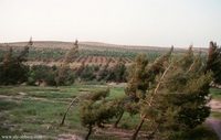
At the southwest end of the 8-mile long lake is the now-uninhabited city of Kadesh. At the northeast end is Homs. Actually, Homs is a couple miles NE of the lake, but the lake is the 'heart' of the town. It’s waters drive grist mills, and many canals are led off into the fields to irrigate gardens and orchards. The forest to the west supplies summer forage for the animals, and wood for building projects. To the east stretches fields where wheat and barley thrive, and, again, pasturage for the animals.
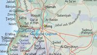
A gap to the west of Homs, called the Nahr al-Kabir valley, allowed caravan travel from the coast at Acre or Tripoli to find it’s way east to Palmyra and finally Mesopotamia. The gap is the result of several geologic faults, with the Lebanon’s to the south and the Jabal an Nusayriyah range to the north. The Jabal an Nusayriyah was an assortment of low ridges and valleys, presenting a rugged separation between the Mediterranean and the interior. Homs sits in a valley with the Orontes finding it’s way to the north. From Homs toward the north, the Orontes begins to entrench itself deeply between steep walls. While the water is not altogether out of reach, it is quite difficult of access after Homs. The Orontes was forded at Homs, before the river built steep walls.
And another valley stretches away from Homs, almost to Palmyra, due east of Homs. This broad valley offered caravans a bit of shelter from the wind and heat of the plateau. It also was the bread-basket for the area, with it’s fertility and adequate water. Looking east from Homs one sees a broad valley lined with steep slopes leading up to table-land, to the north and south. Occasional mesas interrupt the otherwise flat valley bottom, and more than one hidden valley winds a short distance into the slopes. These small valleys often have a small spring which afford meager living for a farmer.
From Homs, the Orontes is forced to flow to the east in a long, broad arc, to avoid limestone outcrops, and basaltic flows. And the river quickly becomes a major obstacle to easy travel. The banks on both sides are planted with melons and vines.
To the south a route climbs into the Antilebanon foothills, winding it’s way south, through valleys to Damascus. This section is mostly dry, uninhabited, and uninviting. The ground is covered with stones and pebbles, and devoid of anything an animal would consider grazing. The valleys, formed of upthrust ridges, may go in parallel lines, unbroken for many miles, and the heat gathered near the bottom is almost unbearable.
There remains little of the city, excepting a few marble columns, evidence of the Roman Era. Without strong central government, the area naturally regresses back to age-old nomadic ways.
Kik voltak a szkíták, 9463. hsz., ugyancsak tőlem:
Emesa: Kr. e. 2300-tól adatolt város Szíriában, az Orontész folyó termékeny völgyében. Egy magaslaton épült, amely átlagosan 508 méterrel emelkedik a tenger szintje fölé. Mai arab neve Hems, Hims, Hums vagy Homs. Jelenleg kb. 650–700 ezren lakják. Híres volt Baál-, illetve Gabal-szentélye, ahonnan Heliogabalus császár egy meteoritkövet hurcolt magával. A keresztes hadjáratok idején a várostól 60 kilométernyire nyugatra épült a Krak des Chevaliers (=Lovagerőd). Fő terméke a selyem, ezenkívül ékszereket, öveket, köpenyeket, műtrágyát, növényi olajat és cukrot állít elő. Haszonnövényei a búza, kukorica, köles, gyapot, valamint az egyéb zöldség- és gyümölcsfélék. A legnagyobb – 43 630 km2 területű – kormányzóság székhelye Szíriában.
Levente: Levante tájegységről a régészeti utalások során Emesa és Arpad városokkal kapcsolatban már szóltunk. Liun-te vagy Hi-liun-te volt a vezértörzs a Huanghótól északra a hunoknál. Erről Szász Béla könyvében lehet olvasni, egyebek mellett. Remélhetőleg nem tévedtem sokat az emlékezetből írottakban (A húnok története – Attila nagykirály; Bartha Miklós Társaság, Bp., 1943; Szabad tér, Bp., 19942, Bakay korrekcióival és kiegészítéseivel).
Arpad, Arphad: Egykori középiskolai térképemen is szereplő ókori város a mai Szíria északnyugati részén. Az Ótestamentum (2Ki 18:34, 2Ki 19:13, Isa 10:9, Jer 49:23, Isa 36:19, Isa 37:13) és az asszír ékiratok gyakran emlegetik. Harcolt vele már III. Ramman-Nirari is, de ami igazán ismertté tette, az a hosszú és kíméletlen asszír ostrom volt fél évszázaddal később. Bobula Ida részletesen tárgyalja, hogyan vesztette el a függetlenségét, miután Mati El (Mati Ilu) nevű királya Urartuval szövetségben Kr. e. 743-ban vereséget szenvedett III. Tukulti-apal-ešarra asszír királytól. A város erődje három évi kemény ostrom után esett el, Kr. e. 740 körül. Az ókori romok ma egy tell homokja alatt fekszenek Erfad, Rif’at vagy R’fat településnél, melybe Veronica Seton-Williams és kutatócsoportja ásott bele az 1950-es, 60-as években.
Mati El… Vajon mit rejthet e személynév? Talán itt is a médekről meg Él istenről lenne szó? Az Élő Istenről, akire nálunk még ma is esküdözni szokás? A Jézus utolsó szavai által megidézett „Éli”-ről, akitől azt kérdezte a Felkent, hogy az miért hagyta el őt? Kuriózumként szúrom ide, hogy a Tokarev szerkesztette kétkötetes Mitológiai enciklopédia szerint az egyik legfőbb hatti istenség neve „Eštan” volt (Gondolat, Bp., 1988)...
Arpad nevét egyesek a héber raphad ’szétteríteni’ igéből származtatják. Érdekes, hogy a nagy hódító hadvezérek születését gyakran olyan álmok jövendölték meg, amelyek például az országokat elárasztó folyamról vagy a nagy térségeket behálózó szőlőtőkéről szóltak.
Arpad városát ún. újhettita államként szokás kezelni, mely a Hettita Birodalom széthullása után létrejövő apró királyságok egyike volt. Karkemiš, Patina, Sam’al, Gurgum, Que, Kummukh, Malatya, Tabal, Arpad… A „Tabal”-ról megjegyzendő, hogy a „Szubar” rontott változata talán, úgy, ahogy ezt Franz Hančar a bibliai „tubal”-ról gondolta. Hančar könyvéről (Urgeschichte Kaukasiens; Anton Schroll & CO.–Heinrich Keller, Wien–Leipzig, 1937) olvastam egy internetes honlapon Arpad városa után nyomozva: „Fundamental work on prehistoric Caucasus”. Lásd: http://www.geocities.com/Eureka/Enterprises/2493/circbibliog2.html.
Arpad város név szerint ismert uralkodói: Gusi (Kr. e. 870 körül), Arame (Kr. e. 858–834), Atar-Shumki (Attarsumk, Attarsamek ’Attar kegyeltje’, Kr. e. 805–796) és utóbbinak a fia, Mati El (Kr. e. 754–740).
Lásd még: Karl Elliger: Sam’al und Hamat in ihrem Verhältnis zu Hattina, Unki und Arpad – Ein Beitrag zu Territorialgeschichte der nordsyrischen Staaten im 9. und 8. Jahrhundert v. Chr.; Festschrift Otto Eißfeldt, Halle, 1947.
A II. Sardur urartui királlyal szövetkező Mati Elről: Also called Tall Rif’at ancient city in northwestern Syria. Arpad is frequently mentioned in the Old Testament and in Assyrian texts. Coming under Assyrian influence in the 9th century BC, Arpad regained its independence in 754, and it successfully sided with Sardur II of Urartu until the Assyrian king Tiglath-pileser III defeated both Urartu and Arpad. Tiglath-pileser made Arpad the capital…
Kr. e. 806–732: With the decline of Damascus, the northern Aramean state of Arpad (Bit Argusi) came to the fore. In 755, King Matiel of Arpad allied himself with Urartu (See 744–727) against the Assyrians, but they were defeated by Tiglath-Pileser III in 743. After a three-year siege, Arpad itself fell. Rezin, the son of Ben Hadad II, allied himself with Israel in an anti-Assyrian coalition. In 732 Tiglath-Pileser defeated the Aramean-Israelite coalition, and Aram, including Damascus, was divided into Assyrian provinces, collectively known as Aram Naharain (See 744–727). This was the effective end of Aram as a political entity, although the Aramaic language subsequently became the lingua franca of western Asia and replaced Hebrew as the spoken language in Palestine.
Tiglath-Pileser's action was swift. By skillful campaigning he completely defeated Urartu in two years and repaired to Syria in 743 to receive tribute. The next year he laid siege to Arpad, which fell after a three year investment. The years 740 and 738 witnessed the sacking of Ullubu and Kullanu and it became evident that Tiglath-Pileser III aimed at nothing less then the liquidation of all states in the Levant (fontos helyrajzi kifejezés – II. Agum) to the border of Egypt.
Arpad (Beit Agusi): Not to be confused with the Phoenician city of Arvad, Arpad was a minor Aramaean state north of Aleppo. Nem tévesztendő össze Arvad föníciai várossal, Arpad kis arameus állam volt Aleppótól (Halebtől) északra.
Arpad Jamkadhoz vagy Aleppóhoz tartozott Kr. e. 2000–1300 körül, utána következett a hettiták mintegy évszázados uralma, majd talán Karkemišé Kr. e. 1200–1000 körül.
A magunk részéről megjegyezzük még, hogy a zsidó nép etnogenezisében a Padan–Aramból származó népelemek meghatározóak voltak. Arvad (görögösen Aradosz, ma Ruad, Eze 27:8, 27:11) partközeli szigeten épült, ahová az édesvizet csatornákon vezették be.
Árpád város neve a magyar „árpa” szóval is összefüggésbe hozható. Annál inkább, mert Árpád-kori személyneveink között a következők fordulnak elő: Búzád, Kölesd, Rusd, Zob, Zoba, Zobas. Fehértói Katalin is gyűjtött belőlük a könyveibe bőséggel. Ráadásul a hurrik és médek által legősibb időkben lakott vidékre esik az Alsó- és Felső-Zab folyó. Az előbbi arabul Zab el-Asfal volt, és egyesek szerint innen a Bíborbanszületett által feljegyzett, Alsó-Zab menti szabart jelentő „szabartoiaszphaloi” név. Ebben a kérdésbe mélyebbre nem mennék egyelőre, sem az „Árpád” és az „Arafat” esetleges etimológiai kapcsolatainak vizsgálatába.
A mai magyarságnak a médek csak egy szerény töredékét adják... Elődeink túlnyomó többsée hunogur, azaz hun-avar nemzetiségű volt (lásd az Árpád-kor köznépi temetőit).
A hattik (szkíták), akiknek egy évszázada, Kr. e. 717-ben foglalta el utolsó önálló elő-ázsiai támaszpontját az asszír II. Šarru-Kenu, a sikeres magyar ostromot követően Ninivét – jogos bosszúvágytól vezérelve – alaposan felprédálták.
Az új, magyar vezetésű birodalom az asszírokkal való hosszas küzdelmek eredményeként jött létre. A döntő fordulat a két állam erőviszonyában akkor következett be, amikor Huvaksatra (akkádul: Umakištar) hadai 612-ben bevették Ninuát, az asszírok fővárosát.
Komoróczy Géza:
615 őszén bekapcsolódtak a háborúba a méd seregek is. Umakištar (Huvahštra, a görög forrásokban Küaxarész, kb. 625–585) lovassága az Alsó-Záb mentén vonult Asszíria ellen. A következő évben, 614-ben Umakistar elfoglalta Aššurt, majd a feldúlt város falai alatt találkozott és szövetséget kötött az ostromot elkéső Nabú-apal-uszur babiloni királlyal. 612 tavaszán a babiloni és a méd sereg összehangolt támadást indított az asszír főváros, Ninua ellen. Három hónapos ostrom után, 612 augusztusában Ninua elesett. Meghalt Szín-sar-iskun, az asszír király is. A várost kegyetlenül feldúlták és elpusztították – ebben valószínűleg döntő része lehetett a szkítáknak is.
Ninua elfoglalása után Asszíria nyugati seregeinek fővezére királlyá nyilvánította magát, és Harrán [később: Carrhae – Avarus] városában, Asszíria nyugati „fővárosá”-ban (a Balih folyó mentén) trónra ült. Hangzatos nevet választott: II. Assur-uballit [= akit Aššur isten életre keltett – Avarus] (612–609); neki azonban nem sikerült nagy elődje tettét megismételni, Assur isten nem keltette életre a birodalmat.


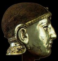 Ezüst bevonatú vas álarc Emesa városából
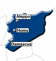 Kr. e. 719-ig valószínűleg Hamath városhoz tartozott. Ezután 612-ig asszír, utána méd, végül 539-ig babiloni érdekövezet volt. A perzsa hódítást makedón uralom követte a 332–323 közötti időben. Kr. e. 301-ig a várost az Antigonidák, 198-ig a Ptolemaidák uralták, őket követték Kr. e. 68-ig a Szeleukidák, majd Róma és Bizánc.
 Rövid története:
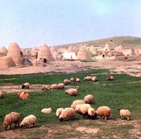
 Emesa városa ma
 Etymology:
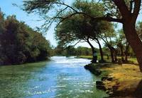
 Földrajza:
 „Emèse”-nek írja a következő honlap:
 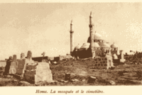 The word „Homs” derives from a Canaanite root that means shyness. A „Homs” szó kánaáni eredetű, és szemérmességet, félénkséget jelent.
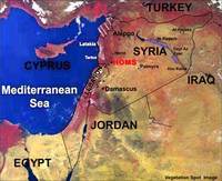 Szíria – műholdról
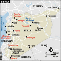
 Emesa (ma: Homsz)
 Emesa: Kr. e. 2300-tól adatolt város Szíriában, az Orontész folyó termékeny völgyében. Egy magaslaton épült, amely átlagosan 508 méterrel emelkedik a tenger szintje fölé. Mai arab neve Hems, Hims, Hums vagy Homs. Jelenleg kb. 650–700 ezren lakják. Híres volt Baál-, illetve Gabal-szentélye, ahonnan Heliogabalus császár egy meteoritkövet hurcolt magával. A keresztes hadjáratok idején a várostól 60 kilométernyire nyugatra épült a Krak des Chevaliers (=Lovagerőd). Fő terméke a selyem, ezenkívül ékszereket, öveket, köpenyeket, műtrágyát, növényi olajat és cukrot állít elő. Haszonnövényei a búza, kukorica, köles, gyapot, valamint az egyéb zöldség- és gyümölcsfélék. A legnagyobb – 43 630 km2 területű – kormányzóság székhelye Szíriában.
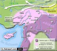
 Arpad, Arphad: Egykori középiskolai térképemen is szereplő ókori város a mai Szíria északnyugati részén. Az Ótestamentum (2Ki 18:34, 2Ki 19:13, Isa 10:9, Jer 49:23, Isa 36:19, Isa 37:13) és az asszír ékiratok gyakran emlegetik. Harcolt vele már III. Ramman-Nirari is, de ami igazán ismertté tette, az a hosszú és kíméletlen asszír ostrom volt fél évszázaddal később. Bobula Ida részletesen tárgyalja, hogyan vesztette el a függetlenségét, miután Mati El (Mati Ilu) nevű királya Urartuval szövetségben Kr. e. 743-ban vereséget szenvedett III. Tukulti-apal-ešarra asszír királytól. A város erődje három évi kemény ostrom után esett el, Kr. e. 740 körül. Az ókori romok ma egy tell homokja alatt fekszenek Erfad, Rif’at vagy R’fat településnél, melybe Veronica Seton-Williams és kutatócsoportja ásott bele az 1950-es, 60-as években.
 Az új, magyar vezetésű birodalom az asszírokkal való hosszas küzdelmek eredményeként jött létre. A döntő fordulat a két állam erőviszonyában akkor következett be, amikor Huvaksatra (akkádul: Umakištar) hadai 612-ben bevették Ninuát, az asszírok fővárosát.
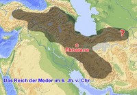
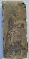 Magyar férfit ábrázoló dombormű Xerxész perszepoliszi palotájából
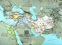 A Méd Birodalom
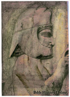 Magyar divatú fejfedő az ókorban
 Méd férfiportré Perszepoliszból („Perzsaváros”-ból)
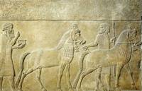 Magyar (méd) követek II. Šarru-kenu asszír király egyik domborművén