After the spread of the Manichaean religion in Khorasan and Transoxiana with the efforts of Manichaean missionaries, the Parthian language was used as a tool for promoting the Manichaean religion and hence books were written or translated in this language. Some of these books have been found in northwestern China. The handwriting used for these texts is the same as the Manichaean handwriting said to be invented based on Tadmori handwriting by Mani himself. The Manichaean handwriting goes from right to left and its main characteristic is lack of Hezvarash which makes this writing very easy to read. Also unlike the Parthian writing in which each letter can have different phonetic values, in Manichaean handwriting each letter can only have one phonetic value. Parthian texts written in Manichaean handwriting are:
Works of Mani and his students: these writings were compiled when the Parthian language was still used (in 3rd or the 4th century AD). The most important work is parts of "Ardahand Vafras" which analyzes Mani's main book, "Arjang".
Mani's recent work: which are usually about the Dinavarieh sect.
It was mentioned that by this time, Parthi was a dead language and that is why in many cases the influence of Middle Persian words and grammar is evident. Manichaean texts written in Parthi language include subjects such as: principles of faith, songs praising God and religious leaders, letters of advice, personal letters, charms, prayers, stories and proverbs. A considerable part of these texts are poems.
Khorenei Mózes egyébként a pártus kor eseményeinek leírásánál ismételten említi ogurokat és a bolgárokat, akik részben Örményországban is letelepedtek. De a VI. században munkálkodó bizánci Agathiasz is arról tudósít, hogy az ő idejében Transzkaukáziában volt egy régi erőd, amelyet Onogurisznak hívtak, mégpedig azért, mert ott hajdanában az onogurokat megverték. Ammianus Marcellinus szerint pedig a szabírok már a IV. század közepén Dagesztánban laktak.
Felettébb jellemző, hogy Khorenei Mózest az indogermán történettudomány – és nyomában természetesen a magyar történelemkutatás is – évtizedeken keresztül késői, VIII. vagy IX. századi kompilátornak tartotta, aki csak visszahazudta magát az V. századba, és úgy írt, mintha akkor élt volna. Fenti régi, parthus kori adatait az ogurokról, bolgárokról nem tudták ugyanis beilleszteni a hunok előtti Kaukázus-vidék – szerintük tiszta „iráni”, alán és egyéb – népei közé. Khorenei tehát csaló lett, ugyanazon okból, mint számtalan más régi krónikás is, akik olyanokat mertek írni, amik ellenkeztek a XIX. századi indogermán történetkutatók előre megfogalmazott nézeteivel.
A modern, tárgyilagos kritika azonban teljes mértékben rehabilitálta Khorenei Mózest. Megállapították, hogy eredeti műve csak 440-ig tárgyalta az örmény történelmet, ami pedig a fennmaradt kéziratban későbbi eseményekről található, az kétségtelenül utólagos interpoláció. (Brockhaus Encyklopädie, 1971, Movses Chorenatzi címszó alatt.)
Sztrabón híradása a parthus dinasztia alapítójának "előéletéről" önmagában természetesen nem jelentheti azt, hogy dák vagy avar (aparnosz) származású lett volna, az örmény források (a VII. századi Szebéosz, továbbá Movszesz Khorenaci stb.) ugyanis az "uraságokat" heftalita-hun eredetűnek mondják. Nem lehetetlen tehát, hogy az avarok Ókhosz menti csoportjának, a dákoknak az élén valóban hun előkelők álltak Diodótosz szatrapa lázadása idején.
---------------------------------------
Mivel Szebéosz a VII., Khorenaci pedig nagy valószínűséggel az V. században élt, arra is gondolhatunk, hogy a heftalita népnevet mindketten egyszerűen csak visszavetítették a múltba, és az avarok (parthusok) neveként használták, tekintettel arra, hogy a Hephthalita Birodalom irányító etnikuma a hun mellett az avar volt (= hun-avar, hungarus, onogur, várkony keveréknép)
Alexander the Great conquered the region in 329 BC and it was called the Καύκασος Ινδικός or Caucasus Indicus by the Greek historians with Alexander the Great
I. Mithadat, a nagy hódító fellépése előtt azonban a parthus főváros nem az Atrek folyónak ebben az elhagyott völgyében állt, hanem Hekatompüloszból, az ezer kapujú városból, a mai Šahr-e Qumisból irányították a királyságot
John Hansman: The Problems of Qūmis; in: Journal of the Royal Asiatic Society 1968, 111--139. o.
John Hansman--David Stronach: Excavations at Shahr-i Qūmis, 1971; in: Journal of the Royal Asiatic Society 1974, 8--22. o.
Markwart ... concluded that the name Abāršahr (q.v., i.e., Nīšāpūr) meant “not the Upper Country but the country of the Aparnak, i.e., the Aparnoi” (Provincial Capitals, p. 52; see also E. Herzfeld, Zarathustra, AMI 1, 1929, p. 82 n. 1, p. 108 n. 1; Christensen, Iran Sass., p. 220; W. Eilers, Demawend, Archiv Orientalni 22, 1954, p. 373).
----------------------------------------
Az Oberndorf-szindróma...
Felsőfalu vagy Avarfalva?
Markwart egyébként Frye véleményével szemben szólalt fel, teljesen jogosan. Az örmény Apar ašxarh, majd később Apar ašxart és az arab Abaršahr jelentése nézete szerint: 'az aparnoszok országa'.
See also 1. Primary sources: Apollodorus of Artemita apud Strabo 11.7.3. Arrian apud Photius 58. Isidore of Charax 11. Justin 41.1.10. Ptolemy 6.10.2. Strabo 8.2., 9.2–3. Trogus 42.1010. 2. Secondary sources: F. Altheim, Weltgeschichte Asiens im griechischen Zeitalter, Halle, 1948, II, pp. 15–16. E. R. Bevan, The House of Seleucus, London, 1902, I, pp. 283-84. M. Colledge, The Parthians, London, 1967, p. 25. N. C. Debevoise, A Political History of Parthia, Chicago, 1938, p. 2. M. M. Diakonov, Aškānīān, Tehran, 1344 ī./1965, pp. 39–41 (translated from the Russian). R. N. Frye, The Heritage of Persia, New York, 1963, pp. 48, 130, 172. B. P. Lozinski, The Original Homeland of the Parthians, The Hague, 1959. E. Meyer, Blüte und Niedergang des Hellenismus in Asien, Berlin, 1925, repr. in F. Altheim and J. Rehork, Der Hellenismus in Mittelasien, Darmstadt, 1969, p. 49. K. Schippmann, Grundzüge der Geschichte der Parther, Darmstadt, 1980, pp. 14–17. W. W. Tarn, The Greeks in Bactria and India, Cambridge, 1938, p. 80. J. Wolski, Der Zusammenbruch der Seleukidenherrschaft im Iran im 3. Jahrhundert v. Chr., l947, repr. in F. Altheim and J. Rehork, Der Hellenismus im Mittelasien, Darmstadt, 1969, pp. 188–254. Camb. Hist. Iran III, pp. 24, 26–30, 187, 686, 689.
Pierre Lecoq szerint a kelet-iráni aparna nyelv egyes maradványai örményországi parthus jövevényszavak formájában élnek tovább, többségük viszont a manicheus parthusban (Encyclopaedia Iranica,1983, Aparna címszó):
„The Aparna originally spoke an East Iranian language, the traces of which survive in some Parthian loan-words in Armenian such as kari (very, cf. Sogd. k' 'y), margarē (sorcerer, cf. Sogd. m'rkry, Parth. m'rygr; cf. W. Henning, A List of Middle Persian and Parthian Words, BSOAS 9, 1937, p. 85, repr. Acta Iranica 14, p. 565; R. Gauthiot, in MSL 19, 1915, pp. 125–29). More Aparna words may be traced in Manichaean Parthian; e.g., hnd (blind, cf. Western Iranian kwr; for other examples see Henning, Mitteliranisch, pp. 93–94). Their language, however, was eventually replaced by Parthian, a Northwestern Iranian language.
No convincing etymology has been yet proposed for the word Aparna. Tomaschek’s derivation from apәrәnāyu-, Pahl. apurnāy is untenable (Pauly-Wissowa, I, 2, col. 2669).”
Some identifications of the Aparna have been tentatively made in Iranian sources. Markwart, quoting a passage in the Bundahišn (p. 233.14–15), concluded that the name Abāršahr (q.v., i.e., Nīšāpūr) meant “not the Upper Country but the country of the Aparnak, i.e., the Aparnoi” (Provincial Capitals, p. 52; see also E. Herzfeld, Zarathustra, AMI 1, 1929, p. 82 n. 1, p. 108 n. 1; Christensen, Iran Sass., p. 220; W. Eilers, Demawend, Archiv Orientalni 22, 1954, p. 373).
But, besides a possible different reading of the key word ÷plnk (cf. Bundahišn, tr. p. 299), it should also be noted that the involved passage in the Bundahišn concerns a person and has little to do with the name of a long forgotten people. M. Sprengling (“Shahpuhr I the Great on the Kaabah of Zoroaster,” AJSLL 57, 1940, p. 399) identified the word Aparna in the inscription of Šāpūr I on the Kacba-ye Zardošt (Pers. 28, ÷plynk, Parth. 23, ÷prynk, Gk. Abrēnach, see also Eilers, ibid.; M. L. Chaumont, in Acta Iranica 4, 1975, pp. 118-19); but this has been rightly rejected (Henning, Mitteliranisch, p. 95, n. 1; Ph. Gignoux, Glossaire des inscriptions Pehlevies et Parthes, London, 1972, s.v.; idem, in Stud. Ir. 5, 1976, p. 308).
Aparna(Gk. Aparnoi/Parnoi, Lat. Aparni or Parni), an east Iranian tribe established on the Ochos (modern Tajen, Tejend) and one of the three tribes in the confederation of the Dahae (q.v.; Dahā in the inscription of Xerxes, Ph 26, see Kent, Old Persian, p. 151). Their original homeland may have been southern Russia from where they emigrated with other Scythian tribes into the Dahestān, south-east of the Caspian sea. Led by Arsaces I, they invaded Parthia around 240 BC, defeated its satrap Andragoras (q.v.), and destroyed several towns. From then on they shared, as a leading aristocracy, the history of the Parthian people. There is some difficulty in exactly identifying the tribes settled in Dahestān. The Aparnoi of Dahestān mentioned by Strabo (11.7.1) should be considered as Sparnoi (Aparnoi is a conjectural emendation of Xylander and Casaubonus). The real Dahestān Aparnoi (var. Eparnoi, Asparioi) should also be distinguished from the Ochos Parnoi (Strabo 10.9.2; see Altheim, Weltgeschichte II, p. 15). The same doubt may arise about Justin’s (41.1.10) Parni or Sparni or Apartani (J. Wolski, Der Zuzammenbruch, p. 206 and note 36).
In various classical sources the Dahae are listed in the rosters of the Persian army that fought against Alexander the Great at Gaugamela (q.v.). Arrian (Anabasis 3.11.37) reported that the Dahae fought in the left wing, together with the Bactrians and the Arachosians. Curtius Rufus (4.12.5ff.) also placed the Bactrians and Dahae in the left wing. In addition, both authors noted that beyond the Persian ranks, at the extreme left, there were Bactrian and Scythian cavalry and scythe chariots (Arrian), or the Massagetae (Curtius Rufus). It is thus clear that the left wing of the Achaemenid army was formed by troops from the northeastern part of the empire, predominantly of Scythian descent, and that the Dahae were one of these groups.
According to his biographers, Alexander later also incorporated Dahae into his own cavalry (Arrian, Anabasis 5.12.2; cf. Curtius Rufus, 7.7.32). They were described as “horseriding” bowmen (cf. Appian, Syriaca 167) and were said to have lived in the wastes northeast of Bactria and east of Sogdiana. At least some of the Dahae must thus be placed along the eastern fringes of the Karakum desert, near ancient Margiana, a conclusion confirmed by information found in some other classical sources (e.g., Ptolemy, Geography 6.10.2; Tacitus, Annales 11.10). It is possible that the Dahae were thus responsible for nomadic invasions of Margiana and Areia some time around 300 BCE, in which the towns of Alexandreia and Heracleia, the first located in Margiana, the latter apparently in Areia, were destroyed (cf. Pliny, Historia Naturalis 6.47-48; 33; 6.67; Strabo 11.516).
The spread of the Dahae farther west, at least by the mid-3rd century BCE, is indicated in other sources, which refer to Dahae who settled in the lands north of ancient Hyrcania, along the southeastern shores of the Caspian Sea. This area was later known as Dahistān (Dehestān). In this connection Strabo (11.508, 11.515) referred to the (S)parnoi (cf. Justin 41.1.10). He also mentioned two other Dahā tribes, namely the Xanthioi and the Píssouroi, who lived east as far as the lands north of ancient Areia (11.511). The (S)parnoi are of particular interest, as elsewhere Strabo reported that Arsaces, the founder of the Parthian empire, who lived around the middle of the 3rd century BCE, was the chief of this Dahā tribe (11.515). Strabo added that the (S)parnoi lived along the Ochus; this reference cannot be separated from another (11.509) to the Ochus as one of the rivers that crossed Hyrcania. All this information suggests that the (S)parnoi lived in or near what was later called Dahistān; at least one ancient tradition linked their presence in this area to the Scythian invasions of Parthia that led to the foundation of the Parthian empire. The ensuing history of the Dahistān steppes and their role as a cradle for future rulers on the Persian plateau (cf. the sequence of Turkmen dynasties in Persia since the Middle Ages) appear to support the hypothesis that these lands formed the basis for nomadic inroads into the plains along and between the Khorasan mountain chains.
When exactly the (S)parnoi or Dahae settled along the southern and southwestern fringes of the Karakum desert remains unclear; they may have moved there in the late 4th or early 3rd century BCE, when other Scythian tribes invaded Margiana and Areia, though the Dahae may have settled in ancient Dahistān much earlier.
It could thus be concluded that the main group of the Dahae resided in the arid steppes of the Karakum, in lands inhabited in recent centuries mainly by Turkmen.
There is no need to assume, however, that the present harsh conditions already existed in the 1st millennium BCE; archeological finds, for example, a fortress of the Parthian period at Igdy along the banks of the now dried-up Uzboi river (Koshelenko, 1985, pp. 211, 214, 216), suggest that the Karakum was far from completely deserted. The Dahae must have been one of those Scythian groups that dominated traffic between Hyrcania and Parthia to the south and ancient Choresmia (q.v.) to the north. Whether or not the Δαoι listed by Herodotus as one of the Persian tribes should be identified with the Dahae of the Karakum remains uncertain, but in the light of other evidence of northern infiltrations onto the Persian plateau and beyond during the early 1st millennium BCE (cf., e.g., the name of the Mardians), it cannot be excluded that Scythian groups, including the Dahae, were present in southwestern Persia at a fairly early date.
Ha pedig egyszer voltak hajasok az erdélyi dahák között, akkor értelemszerűen kopaszok is. Máskülönben nem lett volna értelme a megkülönböztetésnek.
Összevetve ezt Agathiasznak az avar szolgák hajviseletéről szóló tudósításával, rendkívül érdekes megfigyelést tehetünk, ugyanis Sztrabón szerint a makedón iga alól szabaduló aparnoszoknak volt egy daha nevű törzse, s ebből származott a parthus dinasztiaalapító:
„Amikor a Taurusz hegységen túli területeken felkelések törtek ki amiatt, mert Szüria és Média királyai, akik akkor e területek urai voltak, egymás elleni harcukkal voltak elfoglalva, először Baktrianét és az egész vele szomszédos vidéket szakították el helytartói, Euthüdémosz és társai. Ezután Arszakész, egy szkíta férfiú a Daai [lat. Dahae] törzs élén – így nevezik az aparnoszok népének nomádjait, akik az Ókhosz mentén laknak – megtámadta Parthüaiát, és meghódította. Állama eleinte gyenge volt, mert szüntelen harcot kellett folytatnia neki is és utódainak is azok ellen, akiknek földjét meghódították. Az idők folyamán különböző harci sikerek eredményeként egyre újabb szomszédos földeket hódítottak meg, így erre kaptak, és végül az Euphratészen túl fekvő valamennyi terület uraivá lettek.”
------------------------------------
A Sztrabónnál a XI, 7, 1-ben említett Aparnoi eredetileg Sparnoi lehettek, az átírás Wilhelm Holtzmann (Guilielmus Xylander, 1532–76) és Isaac Casaubon (1559–1614) humanista tudósok nyomán válhatott gyakorlattá
A. D. H. Bivar szerint a kaukázusi Dagesztán toponímája sem 'hegyvidék'-et jelent, hanem a dákok népnevének emlékét őrzi:
'Dahae' was preserved in the toponym 'Dahestan'/'Dihistan', a district "on the eastern shore of the Caspian Sea"...
------------------------------
Ezt ugyan a Kaszpi-tó délnyugati részénél elterülő Dahesztánról vagy Dahisztánról jelentette ki Bivar, de véleményünk szerint a kaukázusi Dagesztánra ugyanúgy érvényes. Annak ugyanis nem sok értelme lenne, hogy kifejezetten hegyvidéki környezetben egy térséget Hegyvidéknek nevezzenek el...
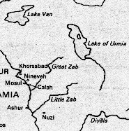
The Great, or Upper Zab (Arabic: الزاب الاعلى; al-Zāb al-A`là, Kurdish: Zê Gewre, Persian زاب بزرگ; Zâb-e Bozorg, Syriac: ܙܒܐ ܥܠܝܐ; Zawa `elaya, Turkish: Büyükzap Suyu, ancient Greek: Λύκος, Lykos; Latin: Lycus) rises in the mountains of southeastern Turkey and flows south for 426 km (265 miles) into Iraq before joining the Tigris south of the city of Mosul at ancient Calah.
The Little, or Lower Zab (Arabic: الزاب الاسفل: al-Zāb al-Asfal, Persian: زاب کوچک; Zâb-e Kuchak, Syriac: ܙܒܐ ܬܚܬܝܐ; Zawa takhtaya; ancient Greek: Καπρος, Kapros; Latin: Caprus) rises in northwestern Iran, in the north of Piranshahr city and flows southwest for 402 km (250 miles) through Iraq to join the Tigris north of the town of Baiji.
Zab (Turkish: Zap suyu, Kurdish: Zê, Persian: زاب; Zâb, Syriac: ܙܒܐ; Zawa) is the name given to two separate rivers that flow through Iran, Iraq and Turkey to become the two principal tributaries of the Tigris. The two rivers, named Greater Zab and Little Zab, were the basis of the ancient Assyrian civilisation.
Noravank church and canyon, as well as Areni wine country are in the wrong direction, but quite worthwhile. Yeghegnadzor has a few monuments in the surrounding area, but some are harder to access. Boloraberd, Spitakavor, Mozrov Caves, and such are not so easily accessible. A bit outside of Yeghegnadzor however are the ruins of Glazdor University and the adjoining monastery. Around Vayk there are restaurants along the river which consist of decks built on its bank set in beautiful surroundings. The Arpa river valley continues south until a number of switchbacks marks the steep ascent to the "Gates of Zangezur" monument, marking the highest point of the road, and beginning the descent towards Sisian.
Férfiasan be kell vallanunk, hogy az Arasznak van egy Arpa nevű bal oldali mellékfolyója, amely érinti többek között Vajk települést...
The Arpa (Armenian: Արփա) is a river that flows through Armenia and Azerbaijan's Nakhichevan exclave. It originates in the Vayots Dzor province (marz) of Armenia and serves as a left tributary of the Aras River. It runs through many cities and towns and is mainly known for its beauty and great locations to watch while fishing or running Arpa river is visible.
Az Amu-darja óperzsa neve egyébként az Araxša volt, ami a Dahestan–Dagesztán párhuzamhoz hasonlóan ismét átvezet minket a Kaszpi-tenger túloldalára.
A képen: az Arasz folyó az Azerbajdzsánhoz tartozó Nakhicseván exklávé területén
A görögök ezt nevezték Araxésznak
The Aras (also known as Araks, Arax, Araxi, Araxes, Araz, or Yeraskh; Armenian: Արաքս, Persian: ارس, Turkish: Aras, Azerbaijani: Araz, Kurdish: Aras or Araz; Russian: Аракс) is a river located in and along the countries of Turkey, Armenia, Iran, and Azerbaijan. Its total length is 1,072 kilometers (665 miles). Given its length and a basin that covers an area of 102,000 km², it is one of the largest rivers of the Caucasus.

 Az örmény írás Mesrob szerzetes fellépése előtt
 A Parthus Birodalom megalakulásának színtere
 The Great, or Upper Zab (Arabic: الزاب الاعلى; al-Zāb al-A`là, Kurdish: Zê Gewre, Persian زاب بزرگ; Zâb-e Bozorg, Syriac: ܙܒܐ ܥܠܝܐ; Zawa `elaya, Turkish: Büyükzap Suyu, ancient Greek: Λύκος, Lykos; Latin: Lycus) rises in the mountains of southeastern Turkey and flows south for 426 km (265 miles) into Iraq before joining the Tigris south of the city of Mosul at ancient Calah.
 A Kura, az Arasz és a Nagy- vagy Felső-Zab folyó
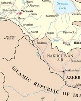 Vajk városa
 A híres dzsermuki ásványvíz, amelyet azonban az USA-ban az idén márciusban levettek a polcokról, mert túl sok arzént mutattak ki benne
 Az Arpa folyó kanyonja Gndevaz falunál
 ... és Dzsermuk városánál


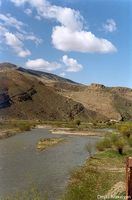
 Az Arpa folyó Vajk városkánál
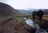 Az Arpa folyó Agarakadzor falu ellett
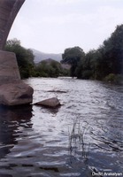 Az Arpa folyó Agarakadzor XIII. századi hídjánál
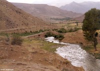


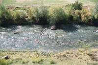
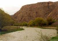
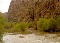
 Az Arpa folyó Areni falu mellett
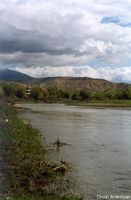
 Az Arpa folyó Arpi városa mellett
 Noravank church and canyon, as well as Areni wine country are in the wrong direction, but quite worthwhile. Yeghegnadzor has a few monuments in the surrounding area, but some are harder to access. Boloraberd, Spitakavor, Mozrov Caves, and such are not so easily accessible. A bit outside of Yeghegnadzor however are the ruins of Glazdor University and the adjoining monastery. Around Vayk there are restaurants along the river which consist of decks built on its bank set in beautiful surroundings. The Arpa river valley continues south until a number of switchbacks marks the steep ascent to the "Gates of Zangezur" monument, marking the highest point of the road, and beginning the descent towards Sisian.
 Férfiasan be kell vallanunk, hogy az Arasznak van egy Arpa nevű bal oldali mellékfolyója, amely érinti többek között Vajk települést...
 Az Amu-darja óperzsa neve egyébként az Araxša volt, ami a Dahestan–Dagesztán párhuzamhoz hasonlóan ismét átvezet minket a Kaszpi-tenger túloldalára.