Hoaxvadász
 2021.03.20 2021.03.20
|
|
-4 1
15329
|
<A talajvíz kinyerésére és távolba szállítására használt qanat vizrendszerek mindenfelé ismeretesek az arab kultúrában, de sokkal messzebb, Kínában, Indiában, Pakisztánban, Iránban, sőt Japánban is.>
itt a rejtélyesben többször is volt már szó a különböző vízgyűjtő, tározó rendszerektől, legutóbb a Göbekli Tepében feltárt csatornákról és ciszternáról:, lásd 15122:
Göbekli Tepe, Turkey. A brief summary of research at a new World Heritage Site (2015 2019)
Left: view towards the west along a channel excavated for a rainwater drainage pipe for the shelter GT2. Right: overview of agglomerated (round-oval) structures revealed in this same trench (cf. Fig. 1, B). (Photos: L. Clare, Göbekli Tepe Project, September/October 2017)"Remarkably, in the following year (2017) the remains of several further agglutinated round house structures appeared on the nearby western slope of the mound during the excavation of a narrow channel for a rainwater drainage pipe (Fig. 1: B. Fig. 3)"
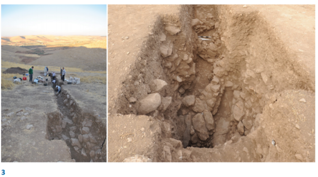 3 Left: view towards the west along a channel excavated for a rainwater drainage pipe for the shelter GT2. Right: overview of agglomerated (round-oval) structures revealed in this same trench (cf. Fig. 1, B). (Photos: L. Clare, Göbekli Tepe Project, September/October 2017) 3 Left: view towards the west along a channel excavated for a rainwater drainage pipe for the shelter GT2. Right: overview of agglomerated (round-oval) structures revealed in this same trench (cf. Fig. 1, B). (Photos: L. Clare, Göbekli Tepe Project, September/October 2017)
"Rainwater-harvesting
A feature from another sounding excavated in 2015 in the northwestern part of the mound could also point to the continued presence of huntergatherer populations at Göbekli Tepe. Located just 15 metres east of building H in the northwest part of the site, a sizeable and still only partially excavated rockcarved pit with a diameter of some 8.0 metres and a depth of 2.8 metres came to light in trench K10-55 (Fig. 1: E. Fig. 6). At present, little is known about the function(s) of this feature, which was found to contain, among other things, large numbers of worked limestone slabs, in some places piled up nigh on to its full height; however, given the evidence of prehistoric ťrainwater-harvestingŤ from the adjacent plateau, including carved channels and ťcisternsŤ in the natural bedrock, its interpretation as a component in an on-site water-acquisition system is a distinct possibility. Support for this interpretation comes from nearby trench K10-35 where a sounding excavated by Klaus Schmidt in 2013 revealed a carved channel in the natural bedrock. Notably, this channel section, located just 12 metres to the west of the new ťcisternŤ, had been carefully protected with a cover of limestone slabs."
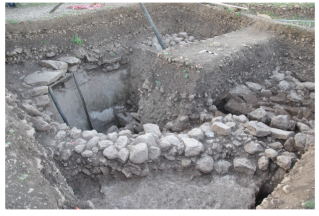 6 A large pit carved into the limestone bedrock is so far unique and might have served as a cistern for the collection of rainwater (cf. Fig. 1, E). (Photo: L. Clare, Göbekli Tepe Project, April 2015) 6 A large pit carved into the limestone bedrock is so far unique and might have served as a cistern for the collection of rainwater (cf. Fig. 1, E). (Photo: L. Clare, Göbekli Tepe Project, April 2015) |
Előzmény: construct (15319)
|
|