Besenyőket és úzokat helyez az Örmény-tenger partvidékére az örmény Matevos Urhayetsi, azaz Edesszai Máté. Ezt a tengert a Van- (esetleg az Urmia-) tóval szokás azonosítani1.
A bennünket érdeklő rész a qūn néphez tartozó türkök vándorlásáról szól, s ebben lényegében ugyanazt írja le, mint a perzsa Marvazí: „Aztán továbbálltak Šārī tartományba, Šārīból pedig a türkmének földjére, akik erre Ghuzz ország keleti részébe mozdultak el. A ghuzz türkök aztán Badzsanāk tartományba vándoroltak, az Örmény-tenger partjainak közelébe.”2
Lényegében csak annyi a különbség, hogy nála az 1050/51. évnél a qūn népnév helyett a többes számú3xartešk’ szerepel4.
A későbbiekben a besenyők és az úzok átállásának tulajdonítja Bizánc 1071. évi manzikerti vereségét.
1 Vö.Henry Hyvernat: Armenia, Past and Present; in: The Catholic World, vol. 62 (1895. dec.), 101.
2 Vlagyimir Fedorovics Minorszkij: Hudud al-Alam – The regions of the world: a Persian geography; Luzac & Co., London, 1937, 29–30.
3 A hehezetes k’ ugyanis az örményben többesképző, vö. a kangarok népnevét tartalmazó, egyes és többes számban is előforduló helynevekkel (Kangar és Kangark')
4 Joseph Marquart: Über das Volkstum der Komanen; in: Willy Bang-Kaup–Joseph Marquart: Osttürkische Dialektsstudien; Berlin, 1914, 54–5. (Abhandlungen der Akademie der Wissenschaften zu Göttingen, Philologisch-Historische Klasse, XIII/1.)
"The Khazars built a fortress, Tmutorokan', at the site of the Greco-Bosporan city Hermanossa (Tamatarcha), on the eastern shore of the Straits of Kerch."
In: Paul R Magocsi: A History of Ukraine; University of Toronto Press, 1996, 45.
Some scholars suppose, that on the Dnieper, the Khazars founded a settlement called Sambat, which was part of what would become the city of Kiev. Chernihiv is also thought to have started as a Khazar settlement.
Hogyan kerülhettek Theophanész folytatójának besenyői (vagy legalábbis a besenyő etnogenezisben részt vevő kangarok) a Don folyó mellé...?
Vásáry István: „A kangarok már 6. századi szír forrásokban előfordulnak a Kaukázusban, a Szevan-tó és a Kura folyó közötti területen. A türk feliratokban szerepel a kengeresz nép, mely ellen nyugaton harcolnak a türk kagánok. Ez a név a kangar és az asz népnevet foglalja magában, mely utóbbi az iráni nyelvű alánok neve. Tudjuk azt is, hogy a Szir-darjának Taskenttől lefelé húzódó alsó folyását Kankar/Kangar néven is illették. Mindezen adatok alapján megállapíthatjuk, hogy a kangarok eredeti lakóhelye az Aral-tó és a Szir-darja középső folyása között, a mai Taskent vidékén lehetett … az 5–6. században lehettek telepeik Transzkaukáziában is … A kangar népnév, mint azt Czeglédy Károly meggyőzően kimutatta, előfordul már a 6. századi szír forrásokban mint egy Kaukázus-vidéki nomád nép neve, s a besenyők kangar neve azt bizonyítja, hogy a besenyő törzsszövetségben kangarok is voltak … Konsztantinosz tehát kora besenyőit a régebbi kangarokkal, a magyarokat pedig a régebbi szavárdokkal azonosította, így egy régebbi kangar–szavárd háború emlékét vetíthette ki a 890-es évek besenyő–magyar háborújára … Bíborbanszületett Konstantin császár a besenyőkről írva megjegyzi, hogy »a besenyőket kangarnak is nevezik, de nem mindet, hanem csak három tartomány népét, Javdiertimét, Küercsicsurét és Kabuksinjuláét, mint akik a többieknél vitézebbek és nemesebbek; mert ezt jelenti a kangar elnevezés«. A Konsztantinosznál különben név szerint feljegyzett nyolc besenyő törzs közül három kangar eredetű volt, s így a besenyő etnogenezisben egy kangar nevű nép is részt vett.”
Ibn Hurradādbih jegyezte fel a Szir-darja Csács alatt kiszélesedő alsó folyásának Kankar elnevezését.
Harmatta János: „540/541-ben Xusro … az onogurok ellen vonult, akiknek neve Mar Aba életrajzának szír változatában a pehlevi ’wngr íráskép … h.ngr értelmezése következtében kangaraye, illetve hangaraye alakká torzult. 540/541-ben tehát valószínűleg egy kis létszámú onogur csoport települt be iráni területre.”
Mar Aba mellett Mar Grigor ugyancsak szír nyelvű Martyrologiumában olvashatunk erről a besenyő etnogenezisben is szerepet játszó népről, az utóbbinál hangar formában. De bello Persico c. művében (II, 15, 35) Prokopiosz ugyancsak beszámol az említett szászánida hadjáratról, azzal az eltéréssel, hogy nála a sahansah a Grúziára törő hunok ellen vonul.
A kangarok/hangarok további sorsáról a Xvadāynāmag(= Királyok könyve) c. szászánida munka Tabarí által készített átdolgozásából értesülünk. Először az abházok, a balanğarok és az alánok szövetségében tört be északról a Kaukázuson át egy banğar nevezetű népcsoport, akiket Kārnāmagjának (= Tettek könyve) értesítése szerint I. Xusrō 541-ben vert le, másodjára pedig már Sir Jibü nyugati-türk kagán alattvalójaként az abkházok és a balanğarok társaságában említi őket a szóban forgó kézirat, 568-ból. „Az arab bnğr (< bangar) íráskép egy középperzsa wngr alakot ad vissza, amennyiben az arabban spiráns v nem volt, s azt általában b-vel helyettesítették” – írja Harmatta János.
Érdemes megemlíteni mégaz 580 körül működő Agathiaszt, aki szerint Sztéphanosz protomártír erődjét azért hívták másként Όνóγουριςnak, mivel ott az onogurnak nevezett hunokat korábban a kolkhisziak csatában megverték. Megerősíti ezt az értesülést a Ravennai Névtelen, aki a VI. század legvége tájékán szintén onogurokat említ az Azovi-tenger és a Kubán alsó folyása vidékén („patria quae dicilur Onogoria”).
Akárhogy is nézzük tehát, a besenyők három kangar törzse Ázsiából jött, a Kaszpi-tavat alighanem délről megkerülve.
Vö. Czeglédy Károly: A kangarok (besenyők) a VI. századi szír forrásokban; in: uő, IV–IX. századi népmozgalmak a steppén;A Magyar Nyelvtudományi Társaság kiadványai 84, Bp., 1954
In the Armenian chronicles of Matthew of Edessa Pechenegs are mentioned a couple of times. The first mention is in chapter 75, where it says that in the year 499 (according to the old Armenian calendar — years 1050–51 according to the Gregorian calendar) the Badzinag nation caused great destruction in many provinces of Rome, i.e. the Byzantine territories.
Ehhez a badzinag csoporthoz verődhetett hozzá tehát (akár még Transzkaukáziában, akár a Kaukázustól északra) a 3 hangar töredék...
Többen a kétes hitelű Dzsagfar Tarihit mint volgai-bolgár forrást is bevonják a vizsgálatokba. Eszerint Kijevet a var-khunoktól a 630-as években függetlenedő Kubrat kagánnak egy Sam-Bat nevű fivére alapította volna. Az ő egyik ragadványneve volt állítólag a Kij, s a város neve így annyit jelentene: 'Kij otthona'.
Az említett bolgár krónika egyébként Árpádról is többször említést tesz a fekete-bolgárok közé tartozó madjarok egyik uralkodójaként, akiknek egy Julaj-Bat nevezetű uralkodójáról is szót ejt a IX. század elejéről.
Eldad HaDani located the Tribe of Dan by the Sambation River which he identified with either the Don River or the nearby Dneiper (Danaper). Constantine Porphyrogenitus (905-959 CE) said that the city of Kiev (founded by kinfolk of the Khazars) was also known as Sambatas.
Kiev was also referred to as Sambatas in DAI. There has been much discussion as to where this name could have come from. One theory is that it derives from the Turkic language of the Khazars and means high fortress (sam-high, bat-strong).
On the other hand, Josephus ("B. J." vii. 5, § 1) says that when Titus marched from Berytus (Beirut) to the other Syrian cities, driving before him the Jewish captives,
"he then saw a river . . . of such a nature as deserves to be recorded in history; it runs in the middle between Arcea, belonging to Agrippa's kingdom, and Raphanea. It hath somewhat very peculiar in it; for when it runs, its current is strong and has plenty of water; after which its springs fail for six days together and leave its channel dry; . . . after which days it runs on the seventh day as it did before; . . . it hath also been observed to keep this order perpetually and exactly; whence it is that they call it the Sabbatic River ["Sabbation" or "Sambation"]—that name being taken from the sacred seventh day among the Jews."
Pliny, also, in his "Historia Naturalis" (xxxi. 2), speaks of the same river; but his observations are more in agreement with the Jewish spirit: he says that the river runs rapidly for six days in the week and stops on the seventh. It seems certain that it was to this periodic river that R. Akiba referred in his answer to Tineius Rufus. When the latter asked him why Saturday was superior to any other day, Akiba answered, "The River Sambation proves it" (Sanh. 65b). This answer is more complete in Gen. R. xi., in Tan., Yelammedenu, Ki Tissa, and in Aha (Ahai) of Shabha's "Sheiltot," Bereshit: "The River Sambation proves it [the superiority of Saturday] because during the week-days it runs and causes stones to drift, but on Saturday it ceases to flow." Pethahiah of Regensburg says that in Jabneh there is a spring which runs during six days in the week and ceases to flow on Saturday ("Sibbub," ed. Prague, p. 5).
The periodicity of this Palestinian river naturally gave rise to many different and fantastic legends. At first the phenomenon was considered to be supernatural; and, though there is no indication in the statement of either Josephus or Pliny that the cessation of the flow of the river occurred on Saturday, a legend arose to the effect that the rapid current and the cessation coincided respectively with the six week-days and Saturday. Even R. Akiba, who dwelt not very far from the river, answered evasively; so that it seems that even in his time there was a confusion between the Sambation of the ten tribes and the Sabbatic River of Josephus and Pliny. The legend did not stop there; in the course of time imagination changed the nature of the river also.
The first to disseminate the legends was Eldad ha-Dani. According to his narrative, the Sambation surrounds the land not of the ten tribes, but of the children of Moses, who have there a powerful kingdom. The origin of this legend is the passage Ex. xxxii. 10; and as in the midrashic version of Akiba's answer it is said that the river causes stones to drift, Eldad represents the Sambation as consisting entirely of sand and stones. His narrative is as follows:(Epstein, "Eldad ha-Dani," p. 5 et passim)
"The Bene Mosheh are surrounded by a river like a fortress, which without water rolls sand and stones with such force that if in its course it encountered a mountain of iron it would grind it to powder. On Friday at sunset a cloud envelops the river [in another version, the river is surrounded by fire], so that no man is able to cross it. At the close of the Sabbath the river resumes its torrent of stones and sand. The general width of the river is two hundred ells, but in certain places it is only sixty ells wide: so that we [on this side of the river] may talk to them [on the other side], but neither can they come to us nor can we go to them".
A similar narrative, though stated from a different point of view, is found in the letter of Prester John (see D. H. Müller, "Die Recensionen und Versionen des Eldad ha-Dani," in "Denkschriften der Kaiserlichen Akademie der Wissenschaft," Vienna, 1892):
"One of the wonderful things on earth is a waterless sea of sand ["mare harenosum"]; for the sand is agitated and swells in waves like every other sea, and is never at rest. At a distance of three days from this sand sea are certain mountains, from which descends a river of stones and without any water. It flows through our territory and falls into the sea of sand. Its current is maintained only for three days in the week; on the other four days the river is fordable. Beyond this river of stones dwell the ten tribes, who, though pretending to have kings of their own, are our subjects."
In the Hebrew version of this letter (see "Kobez 'al Yad," iv. 69 et seq.) the text has been altered to favor the Jews, so that it agrees with Eldad ha-Dani. It reads as follows: "Know that from this stony sea there flows a river the source of which is in paradise. It runs between our territory and that of the great King Daniel. This river runs all the days of the week, and on Saturday it ceases to flow. It contains no water, but it causes everything in its course to drift to the Arenaso Sea ["Mare Harenosum"]. No one can cross it except on Saturday. We are obliged to place guards at the borders of our territory to defend them from the incursions of the Jews."
Thus, even according to the Latin text, the legend of the ten tribes being surrounded by a stone river was current among the Christians also.
Among the different versions of the Alexander legend is one which states that Alexander, when he was journeying toward the south of Egypt, arrived at a river which flowed with water for three days and with sand for three days, and that this was the Sambation of the Jews (Nöldeke, "Beiträge zur Geschichte des Alexanderromans," p. 48). As the narrator was probably a Christian, he does not say that the river ceased to flow on Saturday; but Ibn Fakih, in his Arabic version, adds a statement to this effect (Nöldeke, l.c.). Ibn Fakih is not the only Arab writer who mentions this river; Kazwini ("Cosmography," ed. Wüstenfeld, ii. 17) relates in the name of Ibn 'Abbas thatone night the prophet asked the angel Gabriel to bring him to the land of the children of Moses ("Banu Musa"), who were reputed to be very righteous. Gabriel told him that it would take him six years to reach there and six years to return, and that even if he were there he would not be able to gain access to the Banu Musa, they being surrounded by a river of sand ("Wadial-Raml") which flows with the rapidity of an arrow, resting only on Saturday. Mas'udi ("Prairies d'Or," i. 161) also mentions a river of sand, in Africa. Finally Grünbaum (in "Z. D. M. G." xxiii. 627) concludes that the Sambation legend was current among the Samaritans also.
This legend, interest in which seems to have become lessened in the course of time, was revived in the seventeenth century through the fantastic stories of Gershon b. Eliezer ha-Levi in his "Gelilot Erez Yisrael" and of Manasseh b. Israel in his "Mikweh Yisrael." The former relates that in 1630, while traveling in India, he arrived at Seviliah, two days' journey from the Sambation, where he heard the clattering noise of the river. He says: "It is seventeen miles wide and throws stones as high as a house. On Saturday it is dry; there is then not a single stone, and it resembles a lake of snow-white sand. The Gentiles who dwell near the river do not drink of its water, nor do they give it to their cattle, considering it a sacred river. The water has, besides, a curative power in leprosy and other diseases. The river ceases to flow on Friday, two hours before sunset; and during this interval before the Sabbath the Jews make incursions into the neighboring lands."
Manasseh b. Israel, while endeavoring to prove the existence of the Sambation, states, as a peculiarity of its sand, that even when it is kept in a glass it is agitated during six days of the week and is quiescent on Saturday ("Mikweh Yisrael," x., No. 39).
There are thus essential differences even among the Jews with regard both to the nature of the river and to the people which it surrounds. There is a difference of opinion also as to the locality of the river. It has already been said that, according to the midrashim, the Sambation must be identified with some river of Media, and that Nahmanides identified it with the Gozan of the Bible. Eldad ha-Dani placed it in the land of Havilah in the south of Cush, which, though sometimes denoting India, seems here to indicate Ethiopia; and the same location is to be concluded from the Alexander legend. Pethahiah of Regensburg says (l.c.) that it is distant ten days from Ezekiel's grave, which is itself one day's journey from Bagdad. Abraham Farissol says that the River Sambation is in upper India, higher up than Calcutta ("Iggeret Orhot 'Olam," ch. xxiv.), which opinion was followed by Gershon b. Eliezer; but Manasseh b. Israel ("Mikweh Yisrael," ch. x., xiii.), invoking the authority of ancient writers, thinks that the Sambation is near the Caspian Sea. The only point upon which the above-mentioned authors agree is that the name "Sambation" was given to the river on account of the cessation of its flow on Saturday; and this explanation is given by Elijah Levita ("Tishbi," s.v. "Sambation").
The critical views of modern scholars also differ. Reggio, arguing from the contradictions of the ancient writers, denies the existence of such a river. He thinks that the Sambation of the ten tribes, mentioned in the midrashim, is to be identified with the Euphrates, being so called because the Israelites after settling near that river were able to observe the Sabbath (comp. II Esd. xiii. 43-45). Reggio's opinion may be supported by the fact that the River Don is called by Idrisi "Al-Sabt," while Kiev is called by Constantinus Porphyrogenitus "Sambatas," each term meaning "resting-place," as both places were commercial stations and were so named by the Chazars. Fuenn concluded that the Sambation of the ten tribes is to be identified with the Zab in Adiabene, whither the ten tribes were transported; that the name "Sabatos," as this river is called by Xenophon, was subsequently altered to "Sabbation" and "Sambation"; and that later people confounded the Sambation with the Sabbatic River of Josephus and Pliny, and created many legends about the abode of the ten tribes (see Herzfeld, "Gesch. des Volkes Israel," i. 366). David Kaufmann, without discussing the existence of the river, explains the origin of the name "Sambation" as follows: "The legend originated with a river of sand and stones which, owing to a volcanic cause, might have been agitated. Its Hebrew name was 'Nehar Hol' (= 'river of sand'), equivalent to the Arabic 'Wadi al-Raml.' This name was later misunderstood to signify 'the river of the week-days,' and thus gave rise to the legend of a periodic river which alternated between Saturday and the week-days, whence its name 'Sabbation' or 'Sambation' (= 'Sabbatic river'). As the name does not indicate whether it flows or rests on Saturday, Josephus and Pliny interpreted the matter in contrary senses."
Sambation, Sanbation, Sabbation: In rabbinical literature the river across which the ten tribes were transported by Shalmaneser, King of Assyria, and about which so many legends subsequently accumulated that it was considered by some scholars to be altogether mythical.The name of the river occurs in the Targum of pseudo-Jonathan to Ex. xxxiv. 10: "I will remove them from there and place them beyond the River Sambation." R. Judah b. Simon said: "The tribes of Judah and Benjamin were not exiled to the same place as the ten tribes; for the latter were transported beyond the River Sambation," etc. (Gen. R. lxxiii.). The same statement is found in Num. R. xvi. and Yalk., Gen. 984. There is no indication whatever in these passages as to the origin of the name, nor as to any supernatural phenomenon in connection with the river. The only inference to be drawn from them is that the Sambation or Sabbation was a river of Media. It was therefore identified by Nahmanides, in his commentary on Deut. xxxii. 26, with the Gozan of the Bible (II Kings xvii. 6 and elsewhere).
„Kétségtelen, hogy volt egy periódus, az 50-es és 60-as évek, amikor a Szovjetunióban a steppei típusú leleteket valóban tudománytalanul – a keleti szláv történelem szempontjait és vélt érdekeit »védve« –, ellenségesen kezelték. Ez a – közvetetten érvényesített – direktíva a későbbiekben lanyhult, s lassan elkezdett növekedni az avar, illetve szovjet/orosz terminológiával fogalmazva: preszaltovói típusú leletanyag száma, ezzel egyidejűleg ugrásszerűen megnőtt azon sírok száma is, amelyeket a kelet-európai steppén a 10–13. századi besenyőkhöz és kunokhoz lehet kapcsolni. Szembetűnő viszont, hogy teljesen hiányzanak a közbeeső évszázadokból mindazon lelet együttesek, amelyeket az ősmagyarokhoz lehet kötni; az egy krylosi (Halics szomszédságában feltárt) temetőrészlettől eltekintve egészen 1988-ig1 nem volt egyetlen temető, de még csak egy sír sem, melyet megnyugtató módon a magyarok közel 60 éves steppei tartózkodása emlékének lehetne tekinteni (szórvány kengyelleleteket, öv- és lószerszámvereteket és egy-egy temetkezési szokást leszámítva).2
1 N. M. Bokij–S. A. Pletnëva, Zachoronenie sem’i voina-kocevnika X v. v bassejne Ingula, SA 1988/2, 99–115. A honfoglaló magyaroknál jellegzetes részleges lovas temetkezési formának (lócsontok az emberi lábaknál) a sírmellékletek bizonyos díszítőelemeivel (például az övveret keretelése) és technikai részletekkel (például nitszög ellenzőlemezkével) való együttes előfordulása egyértelműen mutatja, hogy nem 10. századi s nem besenyő temetővel van dolgunk. A temető magyar szempontú értékelése: Mesterházy K., A honfoglaló magyarok hitvilága és a monoteizmus, in Hiedelmek, szokások az Alföldön I, szerk. Novák L., Arany János Múzeum Közleményei 7, Nagykőrös 1992, 89–120.
2 A számításba jövő fontosabb leletek áttekintését, a szóban forgó probléma rövid taglalását ld. Bálint, Archäologie 140, 696. j.; uő, A 9. századi magyarság régészeti hagyatéka, in A honfoglalásról sok szemmel I, Honfoglalás és régészet, szerk. Kovács L., Budapest, 1994, 39–46.”
Дуло — род тюрков, династия гуннов, булгар. Основатель первой Великой империи Хунну Мете (Модэ; Маодунь) происходил из рода хюен. Потомки Мете-кагана отождеств-ляемого с Огуз Ханом, правили у хуннов ок. 700 лет, т.е. с 220 г. до н.э. и до 46 г. н.э. К Мете-кагану восходит и род Ашина, который господствовал в Западно-тюркском каганате и Хазарии более 300 лет. К Мете-кагану/Огуз Хану и его отцу Тюменю восходят генеало-гии почти всех гуннских, тюркских каганов; об основателе Европейской Гуннии Баламире известно, что он в 15-м колене восходил к Мете, а в 5-м к Чичи-кагану, жившему в 46. По Прицаку правящий род гунно-булгар в восходящей линии связан с династией Tu-Ku вели-кохуннского императора Мете (фонетические изменения происходили так: Tu-ku ~ T'u-ko d'o-klak duo-klo Doulo. Младший сын Аттилы Ирнек, например, упоминается как среди предков булгарских ханов, так и венгерских королей династии Арпад. Кроме того, известно, что Арпады по своей узко-этнической принадлежности были из кунок (так названы они в венгерских источниках), пришедших с Кавказа на Дунай вместе с кабарами в IX в., см. ниже. Что род Дуло входил в элиту Хазарии говорит этноним таулас/тулас, которым называли одну из горных областей Хазарии. Ибн-Русте, Худуд ал-алам, Марвази называют "Тулас и Луг_р – 2 области у хазар", "тулас и луг_р – 2 раздела тюрок". Упоминаемых в этих источниках "туласов" И. Маркварт идентифицировал с названием булгарс-кого рода Дуло. Упоминается этот род X в. в письме царя хазар Иосифа в форме "Т_д_лу" как название страны, в которой находится Семендер. Ономастиконим Тулу сохраняется и в кумыкской антропонимии в форме Дулу, близкой к наименованию династии Дуло. По мнению И. Мизиева, в северокавказском топониме названии средневековых областей и городов – Джулат, отложилось "имя племенного
Noha Sinai személynevünk előfordul a kazároknál, valamint az askenázi és szefárd zsidóságnál is, egyesek mégis tagadják a kapcsolat lehetőségét. Vajon miért?
Name Sinai frequently used by Hungarians (Madyars). As we know Khabar tribes from Khazaria, which had Judaic religion, formed a union with Madyars and was their leading military force. It's possible that Khazarian and Hungarian name Sinai have Turkic or Finno-Ugrian origin and have no relation to biblical mount Sinai.
(Érdekes, Anonymus műve felbukkanásához emlékeim szerint bizonyos Sinai Miklósnak is köze volt...)
"melyik folyóról gondolta a szerző, miszerint nagyobb az Amu-darjánál. Ezzel kapcsolatban szeretnék utalni arra, hogy Don alsó szakaszának árterülete elég széles, néhol a 12–15 kilométert is eléri…"
Talán nem véletlenül hasonlították a felsőbb szakaszán néhol még ma is 2 km-es átmérőt meghaladó szélességű Óxosz folyóhoz a "csöndes" Dont a Dzsajháni-hagyományban. A ma már a sivatagba vesző – de egykor talán a Kaszpi- és az Aral-tavat egyszerre öntöző – folyam szétterülő víztükréről egy karakalpak népdal kezdő sorai szólnak:
"Amu-darja széles vize, Barna kislány fürdik benne"
„A besenyők országa és a bolgárok közé tartozó '.sz.k.l-ek országa között van a magyarok határai közül az első határ … Országuk kiterjedt, hossza és szélessége száz-száz farszakh. Egyik határuk a Rúm [Keletrómai]-tengert éri, amelybe két folyó ömlik. Ezek közül az egyik nagyobb, mint a Dzsajhún. Lakhelyeik e két folyó között vannak … A tőlük balra, a szlávok oldalánál levő folyónál egy bizánciakhoz tartozó nép lakik. Mindannyian keresztények, és w.n.n.d.r-nak hívják őket. Többen vannak, mint a magyarok, de gyengébbek náluk. E két folyó közül az egyiket Atilnak, a másikat Dunának hívják. Amikor a magyarok a folyó partján vannak, látják a w.n.n.d.r -okat. A w.n.n.d.r -ok felett, a folyó partján egy nagy hegy van. Ennek a hegynek az oldalánál egy folyó tűnik elő. A hegy mögött pedig egy keresztény nép él, amelyet m.r.dá-nak hívnak. Közöttük és a nádorok között tíznapi járóföldnyi út van … Az a folyó pedig, amelyik a magyaroktól jobbra van, a szlávok felé, majd onnan a kazárok vidékei felé folyik. A két folyó közül ez a nagyobbik.”
Ibn Ruszta világosan két olyan folyóról beszél, amely a Fekete-tengerbe ömlik. Az Atil ennélfogva nem lehet azonos a Volgával, mivel az a Kaszpi-tóba önti a vizét. A P. mesternél megőrződött hagyomány alapján (Dentumoger) ezért joggal gondolhatunk arra, hogy a Rúm-tengerbe ömlő másik folyó a Don. Ez annál kevésbé ütközik ellentmondásba, mivel a mohamedán szerzők a ’folyó’ jelentésű török ätil (etil) szót olykor nemcsak a Volgára alkalmazták1. A Donról konkrétan tudjuk is, hogy az egyik elnevezése az Edil volt2.
Ugyanezt állapíthatjuk meg a szöveg bevezető szakaszát vizsgálva, eszerint ugyanis – mint látjuk – a m.dzs.gh.r-ok országának egyik határa az Al-Duna volt, a másik pedig a Volgánál lakó bolgárok-székelyek és a besenyők földje között húzódott. A kutatás a mai napig – készpénznek véve Marquart 1903. évi azon megállapítását, hogy a besenyők 833-ban még a Volgától keletre időztek3 – abból indul ki, hogy az ellentmondó adatok mindegyike késői betoldás, illetve a X. századi állapotok visszavetítése. Így ignorálják Theophanes Continuatus XI. századi kéziratból ismert munkájának Sarkel 834–37 körüli építéséről szóló megjegyzését, amely szerint az említett kazár erőd „a Tanaisz folyónál van, amely a besenyőket innen, a kazárokat onnan elválasztja egymástól”4. De rendszeresen kétségbe vonják – magyarokra5 vagy normannokra6 vonatkoztatva – Szkülitzész7 és Kedrénosz8 Sarkelről szóló tudósítását is: „Úgy tűnik, hogy ez a védvár igen megerősített, és arra szolgál, hogy besenyők támadását a Tanaisz folyónak annál a részénél feltartóztassa”.
Miután gyértelmű, hogy a kazárok egy nyugat felől veszélyeztető ellenséggel szemben emelték a Don bal partjára Sarkelt9, és az is, hogy sem a besenyők, sem a m.dzs.gh.r-ok szállásterülete nem terjedhetett a Volgán túlra kazár területeken át, az előzőeket is figyelembe véve tarthatatlannak kell minősítenünk Ibn Ruszta szövegének azt az értelmezését, mely a Volga folyónál húzza meg a m.dzs.gh.r-ok keleti határát.
Legfeljebb azt lenne érdemes találgatni, hogy melyik folyóról gondolta a szerző, miszerint nagyobb az Amu-darjánál. Ezzel kapcsolatban szeretnék utalni arra, hogy Don alsó szakaszának árterülete elég széles, néhol a 12–15 kilométert is eléri…
1 Zimonyi István: A volgai bolgárok és a volgai út; in: Piti–Szabados szerk.: „Magyaroknak eleiről” – Ünnepi tanulmányok a hatvan esztendős Makk Ferenc
tiszteletére; Szeged 2000, 701.
2 A tatárok még a XV. és XVI. században is így hívták a folyót: Németh Gyula: A honfoglaló magyarság kialakulása; Akadémiai, Bp., 1991, 219. Vö. Engel Pálnak a História c. folyóiratban (1990/56) közölt véleményével: „Etelköz neve … kifejezetten a Donhoz vagy a Volgához kapcsolódik, mert ezt a két nagy folyót nevezték a bolgár-törökök Etilnek.”
3 Joseph Marquart: Osteuropäische und ostasiatische Streifzüge; Lipcse, 1903, 28.
4 Theophanes Continuatus: Χρονογραφια; Weber, Bonn,1838, 122.
5 Carlile Aylmer Macartney: The Magyars in the Ninth Century; Cambridge University Press, London, 1930, 74–5.6 John Bagnall Bury: A History of the EasternRoman Empire; 414–8. Dvornik: Les légendes; 172–4. Vasiliev: The Goths in the Crimea; 109.
7 Ioannes Scylitzes: Synopsis historiarum; Walter de Gruyter, Berlin–New York, 1973, 73. (Corpus Fontium Historiae Byzantinae 5.)
8 Georgius Cedrenus, Ioannis Scylitzae ope; Weber, Bonn, 1839, 129.
9 Михаил Илларионович Артамонов: Саркел и некоторые другие укрепления в северо-западной Хазарии; in: Советская археология VI (1940), 130–67. Uő: Хазарская крепость Саркел; Acta Archaeologica Academiae Scientiarum Hungaricae VII (1956), 321–41.
P. mester a héber Ámosz személynévről gyártja szokásos naiv etimológiáját. Szerinte a 819-ben született boebodosz egy álomlátás következtében a magyar álom vagy pedig a ’jótékony, kegyes’ értelmű latin almus szóról kapta a nevét.
A Bulcsúról szóló topikban a Képes Krónika Berekájának nevéről mutattuk ki, hogy eredetibb formája a Barukh személynévnek. Másik eredetmondánk főszereplőjét a héber berakhah ’áldás’ névvel illették tehát.
Az elbeszélés szerint a hunugurusok és a magyarok megszemélyesítőjeként szereplő testvérpár a perzsa földekről kijőve s a maiótiszi ingoványokon túljutva Bereka fiainak a nőit rabolta el gyerekestül, az alán Dula fejedelem két leányával együtt. A szerző az előzőekhez hozzáteszi, hogy a nőrablás akkor történt, amikor az asszonyok és gyermekeik a kürt ünnepét ülték.
A kürtharsogás napja (jom truá) egy jellegzetes zsidó szertartás. Felvetődik a kérdés: Dul / Dula fejedelemnek, akinek két lánya a monda szerint ugyancsak az ünneplő sokaságban forgolódott, lehet-e köze vajon a júdaizmushoz, és az erdélyi gyula nem a zsidó hitről tért volna-e az ortodox hitre át, amikor Bulcsú példáját követve megmártózott VII. Konstantin keresztelőmedencéjében? Elképzelhető, hogy a m.dzs.gh.r vezetőréteg kazár hatásra vagy inkább a kazár birodalmi elitbe jutva, immár annak részeként vált júdaistává, s adta fel tűzimádó vallását.
Ibn Ruszta adatközlője még azt jegyezte fel: „A m.dzs.gh.r-ok tűzimádók.” Ha elfogadjuk a 870 körüli időpontot Dzsajháni tudósításának idejéül, és a 880-as évek elejét a kabarok csatlakozására terminus ante quemként, akkor Árpád meghódolása feltétlenül e két dátum közé lenne helyezendő. Ehhez persze feltételeznünk kellene, hogy Ibn Ruszta és Gardízí tudósítása a Kijev–Don környéki m.dzs.gh.r nép egészére s nemcsak a közrendűekre értendő.
Egyelőre a 880-as évek legeleje látszik biztosabbnak mint olyan időpont, amelyet követően a Kazár Birodalomhoz történő csatlakozás a kijevi magyarok részéről már nem jöhet számításba. Egyúttal megfontolásra érdemesnek látom azt a nézetet, amely szerint a DAI szó szerinti értelmezésétől eltérően nem Árpád, hanem Álmos kapta volna meg valójában az „arkhóni” címet a kagántól, és a császár a fiatalabb uralkodót csak valami egyéni szimpátia alapján helyezte volna előtérbe. (A Nikétasz Szklérosz-féle hadi vállalkozás és a dunai-bolgár kagán leverése okán?)
Megerősíti ebbéli gyanakvásunkat az említett tényező, hogy Álmos már héber személynevet viselt. Eszerint a m.dzs.gh.r vezetőréteg még Kijevben, Álmos udvarában (PVL: „на горе, ныне зовущейся Угорской, где ныне Олмин двор”) vette volna föl a X. század második feléig őrzött zsidó vallást.
Érdemes lenne elgondolkodni rajta, miért éppen az erdélyi m.dzs.gh.r gyula lányát, Saroltot vette nőül az ugyancsak kikeresztelkedő – bár édesatyjához hasonlóan egyszerre talán más isteneknek is áldozó – Balkh (Waic) m.dzs.gh.r király.
Figure 1.: Godīn Tepe. Plan of the Godīn II structures
Figure 2.: Tepe Nush-i Jan. Plan including the four principal buildings: the Central Temple (1), the Western Temple (the Old Western Building) (2), the Fort (3), and the Columned Hall (4)
Figure3.: The stepped triangular sanctuary of the Central Temple at Tepe Nush-i Jan. The partly reburied fire altar stands in the foreground
The rise of the Medes and the Achaemenids, the first and second Iranian dynasties was in part a product of changes that took place far beyond the bounds of the ancient kingdoms of the Near East. The establishment of Indo-European populations on the steppe lands west of the Tien Shan, followed by the emergence of pastoral economies based on horse riding, served to bring successive waves of invaders into more fertile lands to the south. At least as early as 2000 BCE, the long-established Bronze Age settlements located southeast of the Caspian Sea became subject to external attack, and anywhere from five hundred to a thousand years later the main body of the Iranian tribes can be presumed to have established themselves on the upland plateau that today bears their name. Among such invaders it was the Medes of Iranian stock, close cousins of the Persians, who assumed the dominant role in the early 1st millennium BCE
Unfortunately many of the details that contributed to this pattern of events may never be known to us. While the Medes were likely to have been present in mainland-Iran well before the Assyrians first encountered them in 835 BCE, it remains unclear how the earliest Medes, let alone the early Iranians as a whole, should be distinguished in the archeological record. Even during the next two to three hundred years-years that saw the eventual integration of Median and non-Median elements in the Median kingdom of Cyaxares (ca. 625-585 BCE)-the firm identification of one or another site as specifically "Median" is necessarily hazardous. Any search for a strictly Median component in the material culture of western Iran in the Iron III period (ca. 800-550 BCE) should probably concentrate on evidence from sites not too distant from the Median capital of Ecbatana, now the city of Hamadan.
It is striking to observe that, within these boundaries of time and space, virtually nothing was known of Median dynasty material culture prior to the mid-1960s. The French excavations of C. Virolleaud and C. Fossey, begun at Hamadan in 1914, were never resumed, and in the absence of any other major investigation in the immediate area for more than half a century, all but the most recent general studies focus on the late Achaemenid or post-Achaemenid rock-cut tombs of the western Zagros as the most tangible reflection of Media's once prominent place in Asian history.
During the past twenty years the search for the Median dynasty on the ground has been largely concentrated within the "Median triangle," the region bounded by Hamadan, Malayer and Kangavar. At Godīn Tepe, located 13 km east of Kangavar on the left bank of the Gamas Ab, it is evident that a substantial Bronze Age site was reoccupied after an interval of about five hundred years, close to the beginning of the Iron III period. Here the excavations of T. C. Young, Jr., begun in 1965, have exposed the remains of a series of monumental mudbrick buildings presumed to be part of a single, eventually quite substantial, local ruler's residence (T. C. Young and L. D. Levine, Excavations of the Godīn Project: Second Progress Report, 1974, p. 35).
The two main halls of this Godīn II settlement (Figure 1) exhibit contrasting proportions. While the smaller hall, at the western edge of the surviving plan, is emphatically rectangular in shape and once possessed two rows of four columns, the larger, older, almost square reception hall originally contained five rows of six columns. This last structure is distinguished by several fixed installations: a bench marks the side and rear walls and is complemented, at the back of the hall, by a raised square hearth set approximately opposite an elevated seat and footstool.
The northeastern corner of the extant plan at God-in Tepe includes a building of quite a different character. Its ground plan is taken up by two opposed ranges of six narrow storerooms, each of which probably had a vaulted ceiling. Directly outside the southwest corner, rather than within the building itself, a broad staircase provided access to an upper story. The external north wall of the building, which was erected in two separate stages, also served to extend the fortified perimeter wall that ran along the precipitous north limit of the site.
The parallels that can be adduced for the Godīn halls are not without interest. From Hasanlū IV, within the Iron II period (ca. 1100-800 BCE), there is abundant evidence for rectangular columned halls with two rows of four freestanding columns. The Hasanln halls also exhibit permanent internal fixtures akin to those found in the larger hall at God-in. Nevertheless the God-in halls are by no means carbon copies of those from Hasanlū , nor indeed of the late Iron II columned hall of Baba Jan III, which has itself been claimed as Median (cf. C. Goff, "Excavations at Bābā Jān: Pottery and Metal from Levels III and II," Iran 16, 1978, pp. 40f.; cf. also Art in Iran i). Unlike these earlier partly residential halls, the two God-in halls may have been reserved for purposes of reception alone. Moreover, the spacious plan of the larger hall can be compared to one substantially later monument, Palace P at Pasargadae, which dates to the second half of the 6th century BCE (D. Stronach, Pasargadae, Oxford, 1978, pp. 78f.). At the same time, most of the close parallels for the architecture and the pottery of Godīn II come, not surprisingly, from the adjacent and partly contemporary site of Tepe Nush-i Jan (Nuš-i Jān) (ca. 750-550 BCE).
The excavations at Nush-i Jan, located 14 km west of Malayer, have uncovered most of a compact settlement (Figure 2) that appears to have been at least partly religious in character. The site's four principal buildings consist of the central temple, the western temple, the fort, and the columned hall; they were probably constructed in that order and predate the squatter occupation of the first half of the 6th century BCE
The tower-like central temple, built on what was at first a bare, steep-sided rock outcrop, occupies a commanding position more than 30 m above the level of the surrounding plain. The internal plan includes a single narrow entrance, an antechamber, a ramp leading to an upper room, and a stepped triangular sanctuary, 11 x 7 m2 in area, which once rose to the full height of the building. The altar, which stands within the western bay of the sanctuary, is 85 cm high with four projecting steps and a shallow hemispherical fire bowl at the center of its broad flat top (Plate III). The western temple, which for a time faced the central temple across an open court, is distinguished by a different orientation and an oddly asymmetrical plan. Nevertheless it contains a similar set of rooms: an antechamber, a spiral ramp leading to a room above, and an inner cella with the possible remains of a further altar. The so-called fort, a two-story structure that seems to have combined the functions of a storehouse and a residential unit, is the largest of the buildings found at Nush-i Jan. The well-preserved ground-floor plan includes a single entrance, a guardroom, a ramp-staircase of some size (which may have taken two complete revolutions to reach the level of the upper, now-vanished residential story), and four narrow storage magazines, each of which once stood nearly 6 m in height. The fourth major structure, the columned hall, is an irregularly shaped building approaching 20 x 15 m2 in area. Its flat roof originally rested on three rows of four wooden columns, and its only fixed furnishing consisted of a low mud-brick platform set close to the south wall. The height of the hall may have reached 8 or 9 m. In sum, the main impact of this architecture came from soaring buttressed, recessed, and no doubt crenelated, mud-brick walls. Narrow window openings and tall arrow slots also marked many external walls, while the stark design of one imposing structure-the central temple at Tepe Nush-i Jan provides a notable, if mute, expression of religious belief and practice.
Mud brick was the outstanding medium of construction, although wooden door lintels complement the obviously extensive use of wood in each columned hall. The standard mud brick, at least at Tepe Nush-i Jan, measured 40 x 25 x 13 cm, while the curved vault struts, such as were used in pairs to span distances of up to 2.35 m were often 1.18 m in length. Somewhat against expectation-particularly since large stone column bases can be seen at Ziwiyeh (Zī-wīya)-worked stone was hardly employed; instead the Median brickmason was often prepared to make unexpected, even daring use of the malleable properties of brick and plaster. This determination to build wherever possible with mudbrick elements, including curved vault struts, recalls a similar inclination in the less forested regions of the east Iranian world. The architecture of the Medes came to combine the extensive dependence on mud brick and plaster that was to remain a fixed feature in the arid zones of the East with the interest in wooden columnar construction that took a strong hold in the northern Zagros from the beginning of the Iron Age onward.
The family of ceramics represented in the Median levels -at Tepe Nush-i Jan seems to be associated with the moment that the Medes consolidated their power in the vicinity of Ramadan in the second half of the 7th century BCE Four separate wares are recognized. "Common ware" vessels are buff, cream, or light red in color, often with a distinctive gold or silver mica temper; they include bowls with horizontal handles, small jars with single or opposed vertical handles, a few larger types of jar, and, largest of all, a form of elegant ribbed pithoi. Only smaller, often more elaborate vessels were produced in "grey ware," and these frequently display a carefully smoothed, even burnished surface. "Cooking ware" is represented by a single form: a wide-mouthed cooking pot, handmade with a heavy concentration of quartz or mica in the temper. "Crumbly ware" is also represented by a single handmade product: a tray-like dish with flakes of gold-colored mica in the temper.
Pottery of this kind is well represented in the Malayer plain. Apart from its general resemblance to that found in Godīn II and Baba Jan II, its distribution suggests that the monumental administrative and religious centers of the Medes were matched by modest but nonetheless permanent villages (cf, R. Howell, "Survey of the Malayer Plains," Iran 17, 1979, pp. 156-57). If the plant remains recovered in part from the squatter settlement at Tepe Nush-i Jan may be used as a guide, the economy of these villages was based on such crops as two-row and six-row hulled barley, emmer, bread wheat, peas, lentils, and grapes. The still generously forested mountains provided an extensive range of game, but animal husbandry remained prime; the domestic bone sample at Nush-i Jan included nine species, the most common of which were sheep, goats, pigs, and cattle. There are also indications, entirely in keeping with the age-old repute of the grasslands of Media, that horse breeding already played a significant role.
Our knowledge of the Median occupation at Hamadan itself remains slight. For the moment we not only lack any evidence for stone reliefs or other worked stone elements such as would substantiate the existence of a former "court school" of Median stone carving intermediate between that of Ashurbanipal and that of Cyrus, for instance, but the chance and clandestine excavations that have inevitably taken place in Rama-danover the years have failed to reveal any Median goldwork. If, however, the latest gold vessels from Mārlīk can be ascribed to a date near 700 BCE (O. W. Muscarella, "Fibulae and Chronology, Marlik and Assur," Journal of Field Archaeology 11 /4,1984, p. 417), Median art promises to provide an almost direct link between the vigor of earlier Iranian art forms and the measured refinement of Achaemenid art.
Nush-i Jan I – The Major Buildings of the Median Settlement
Peeters, Leuven, 2007
This second published fascicule of the Final Report on the excavations at Tepe Nush-i Jan, in western Iran, provides a summary log of the five seasons of excavation conducted between 1967 and 1977 as well as a comprehensive description of the nature of the monumental, exceptionally well preserved buildings of the site's main Median occupation. The excavations at Tepe Nush-i Jan were sponsored by the British Institute of Persian Studies and the present account is co-authored by David Stronach, who directed the project from its inception, and by Michael Roaf, who served as the assistant director for all but the first of the five seasons. At a time when most of the colorful Herodotean version of Median history is being increasingly doubted, and at a moment when even the existence of a unified pre-Achaemenid Median kingdom is being seriously questioned, the authors contend that one of the best guides to the contributions that the Medes themselves made to the history, religion and material culture of Iran in the 7th and 6th centuries BC is likely to come from the identification and excavation of further sites from western and northern Iran that can be shown to share certain of the more distinctive characteristics of the extensively excavated Median settlement at Tepe Nush-i Jan.
Róheim Géza: „Valószínű, hogy ... a »genus Turul«-ból való fejedelem anyját mindig a turulmadár ejtette teherbe, mint például a fáraó anyját a napisten.”
In: A kazár nagyfejedelem és a turulmonda (Ethn. XXVIII, 1917, 68., 5. jegyz.)
Albania is the Medieval Latin name of the country which is called Shqipëri by its inhabitants. In Medieval Greek, the country's name is Albania besides variants Albaētia, Arbanētia. The ultimate origin of the root Alb- has been traced to an Illyrian (alb "hill"). In the 2nd century BC, Polybius's History of the World mentions a tribe named Arbon in present-day central Albania. The people who lived there were called Albanoí and Arbanitai. Another suggestion is derivation from the Illyrian tribe of the Albani recorded by Ptolemy, the geographer and astronomer from Alexandria who drafted a map of remarkable significance for the history of Illyria. This map shows the city of Albanopolis (located Northeast of Durrës) which was later called Albanon and Arbanon. In his History written in 1079-1080, Byzantine historian Michael Attaliates was the first to refer to Albanoi as having taken part in a revolt against Constantinople in 1043 and to the Arbanitai as subjects of the duke of Dyrrachium. During the Middle Ages, the Albanians called their country Arbër or Arbën and referred to themselves as Arbëresh or Arbnesh. As early as the 16th century, a new name for their home evolved among Albanian people: Shqipëria, popularly interpreted as "Land of the Eagles" or "Land of the Mountain Eagle" hence the two-headed bird on the national flag, though most likely the origin lies in Skanderbeg's use of the Byzantine double-headed eagle on his seals.


 Az idézett sorok Theophanész krónikájának folytatójától
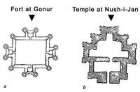 A türkmenisztáni Gonur-tepe erődjének alaprajza és egy templom alapvonalai Nush-i Janból (Sarianidi nyomán)
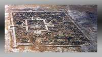
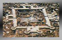
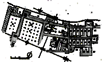 Figure 1.: Godīn Tepe. Plan of the Godīn II structures
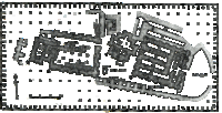 Figure 2.: Tepe Nush-i Jan. Plan including the four principal buildings: the Central Temple (1), the Western Temple (the Old Western Building) (2), the Fort (3), and the Columned Hall (4)
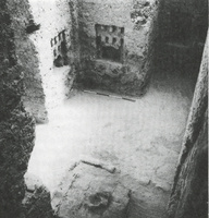 Figure3.: The stepped triangular sanctuary of the Central Temple at Tepe Nush-i Jan. The partly reburied fire altar stands in the foreground
 David Stronach–Michael Roaf
 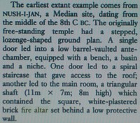 A legkorábbi ismert tűztemplomot Nush-i Jan méd rétegében tárták fel, Hamadántól mintegy 60 kilométerrel délre