[1] G. A. Koselenko and V. I. Pilipko, "Issledovannie parfjanskogo svjatilisca vo okrestnostjach Nisy," Karakumski Drevnosti 2 (Ashkhabad, 1958, 30-35. G. A. Koselenko and G. Gubaev, "Issledovannie parfjanskogo svjatilisca Mansur-Depe v rannesrednovekogo zamka Ak-Depe," Karakumskie Drevnosti 14 (Ashkhabad, 1970/, 89--104.
[2] W. Andrae, Hatra, 2 vols. Leipzig, 1908, 1912.
[3] R. Ghirshman, Terrasses sacrees de Bard-a Nechandeh et Masjid-i Soleiman, MDAI 45 Paris 1976/; D. Stronach, Pasargadai (Oxford, 1976).
[4] D. Schlumberger, Der hellenisierte Orient: Die griechische and nachgriechische Kunst au(3erhalb des Mittelmeerraumes (Baden-Baden, 1969).
[5] J. M. Gagosidze, "Iz istorii gruzino-iraniskich vzwaimootnosenie," Kavkaz i srednaja Azija v drevnosti i srednevekov'e (Moscow, 1981 ), 102-15.
[6] A. M. Apakidze, G. 1. Gobedcisveli, A. N. Kalandadze, G. A. Lomtatidze, Mzcheta, vol. 1 (Tbilisi, 1958).
[7] S. P. Tolstov, Po drevnem Del'tam Oksa i faksarta
(Moscow, 1962), pls. 43, 51.
[8] G. A. Pugacenkova, "Puti razvitija architektury juznogo Turkmenistana pory rabovladenija i feodolizma," Trudy juzno-Turkmenistanskoj archaeologi6eskoj kompleksnoj ekspedizii 4 (1958/, 69-117.
[9] Tolstov, Po drevnem, pls. 58-63.
[10] V. 1. Sarianidi, Baktrisches Gold aus den Ausgrabungen der Nekropolen von Tillja-Tepe in Nordafghanistan (Leningrad, 1985).
Parthian Monuments of the Greater-Iran Introduction
The problem of "Parthian" art is fairly often argued in relation to monuments found in mainland-Iran and Mesopotamia dated in the period of Parthian dynastic domination, while several important sites in northwest and northeast of the Greater Iran, i.e. in Central Asia and Transcaucasia have received much less attention if mentioned at all. The language barrier to using Soviet publications has meant that excavations made even decades ago have not received the attention they deserve. Here I limit myself to two temple sites and one residential, those of Mansur depe, Dedoplis Mindori, and Nisa, although others are mentioned in connection with them.
The two temples of Mansur-depe and Dedoplis Mindori are open air monuments; that is, the largest element of each is an unroofed court. No similar structure has been found, at least until now, at Nisa. But Mansur-depe is sufficiently near that site to be taken as a central sacred place in connection with the residence of Parthian kings at Parthava-Nisa, known as Mithridatkert, and we will see several trends in its architecture which connect it with Hatra and Ctesiphon. Koshelenko dates the Mansur-depe temple on the basis of the ceramic material to the last centuries BCE although it may have continued in use until the end of the Parthian dynasty.[1][1]
Mansue depe (Mansūr Tepe)
Mansur-depe is located near the road from Ashkhabad to Firuz, about five kilometers from Nisa. A court 175 meters from west to east and 160 meters from north to south (fig. 1) was found in the center of the town (of undetermined size; the site was only tested. The enclosure, measuring 190 x 170 meters, is much smaller than that at Hatra (456 x 320 m/, but the similarity is beyond doubt.
The court at Hatra first was thought to be a caravanserai,[2][2] but examinations of Pasargadae and Bard-i Neshandeh[3][3] support the utilization of the courts for Iranian cult practices. Their importance may be seen as similar to that of the Kafir "dancing places" of today.
Both Hatra and Mansur-depe contain large ivan (ayvān)style buildings, at the sides of the courts, which Andrae took to be palaces. But the excavations of the Department of Antiquities of Iraq at Hatra since 1951 have proved that they were shrines, part of the temple of the sun god.[4][4] The same must be true for the structure at Mansur-depe. As at Hatra, ivans are the dominant architectural features; their basic ritual character seems to be beyond doubt.
The organization of space is different from that at Hatra. Instead of Greco-Roman temples, the buildings are of the eastern type with circumambulatory corridors (fig. 2). Those at Mansur-depe were built into the corners. The northwestern building is approximately 7.5 meters square. The southwestern structure was not excavated. Uncovered in the northeastern corner was an ivan with abutting corridors, 7 meters square. The most interesting building was found at the southwestern side. It was dominated by a large ivan that opened on the court. The plan of this main structure at Mansur-depe can be compared favorably with the Taq-i Kisra at Ctesiphon, rather than with the Hatra "palace." The main rooms of both are more or less similar, an ivan before a rectangular, walled hall. They differ in size: that at Ctesiphon measuring 49.92 x 26.25 meters, at Mansur-depe 9.50 x 8 meters.
Fragments of wall painting and stuccowork were found at Mansur-depe, but they have not been published.
Daniel Schlumberger identified Hatra with the city of Shamash, the Semitic form of Mithra, the sun god. What of Mansur-depe? It could have been the site for the Mithras fire. Was it, then, Mithridatkert? The equating of the southwestern building at Mansur-depe with the Sasanian palace at Ctesiphon might be taken as an argument against the ritual interpretation of the Hatra structure, particularly since otherwise we do not have a palace at Hatra.
The Mansur-depe "palace" provides the Parthian prototype for Ctesiphon. The royal residence of the Sasanians had a ritual character as the residence of the "ruler of the world" whose throne stands on the "giant" Bahāristān carpet filling the floor as a "garden;" the symbol of the world.
The Parthian kings may have been identified, or at least connected, with Mithras, as shown by the many theophoric names. Mithras seems to have been the god of the dynasty, and, hence, Mansur-depe may have been the location of the Parthian dynastic fire of Mithras, much like the Shamash temple at Hatra.
Dedoplis Mindori
Another open air temple complex of Parthian times was found in eastern Georgia at Dedoplis Mindori (fig. 3/).[5][5] It stands in the valley of the Pron River, a tributary of the Kura. The complex covers an area 255 x 135 meters, the long side on the north-south axis. An open court, 104 meters square, occupied the central section of the complex. Three buildings were grouped on the northern side. In the center was an ivan temple, and three similar halls stood in the northeastern corner. The main temple seems to have been on the southern side, a brick structure 46 x 30 meters. The cella was square, 17.2 meters in area, the promos 17.2 x 11 meters. Four pillars, perhaps of wood on post-Achaemenid bases (fig. 4), carried the roof of the portico. On the western side, as on the eastern, was a temple of identical plan: an open hall with four columns and a hall with two columns on the court side. There is a (non-correlated) carbon-14 date of 115 BCE from an unidentified side.
The Iranian character of this temple is indisputable, while its size indicates the importance of the site which may have been a northwestern center of the Parthian empire. Parthian influence is found even further to the west. The graves of the "Pitiaxes of Armasi" (the Castle of Ahura-Mazda) in central Georgia[6][6] contained gems and silver work showing Parthian influence, such as the Aspauroukis gem (fig. 11) and the plates with horses standing in front of an altar.
Large areas serving as ritual centers are known from southern Choresmia, the low mountains of Kiiseli-Gyr and Kalaly-Gyr[7][7] dated to the sixth and fifth centuries BCE; the first square, the other triangular. Both must have been ritual centers of the early Saka federation.
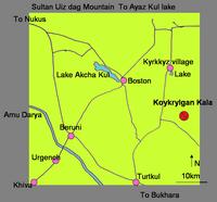
Similar connections with the northern steppes and Choresmia can be found in the architecture of Parthava-Nisa, a proto-Parthian settlement that may have been the center of the Achaemenid satrapy of Parthava. After the Parthian occupation, a royal palace (now known as Old Nisa) was built beside the settlement New Nisa) /fig. 5/. Old Nisa stands on a platform about 7 meters high (fig. 6/. The fortification wall had five corners and was set with towers. The northeastern side measured 350 meters, the northern side 100 meters, the southwestern side 540 meters, and the southeast side over 250 meters. A massive bastion was erected in the southeast corner. Two ramps led up to the entrance of the fortress.[8][8]
Nisa
A good deal has been written about the buildings of the citadel, but many problems still remain (figs. 7, 8/. A long building at the southeastern wall is thought to have served as a barrack. In the northern part stood a quadrangular house, 59.7 meters on a side. Twelve chambers enclosed a 38 meter square courtyard with peristyle. The chambers, of equal size, had clay benches along the walls and four columns supporting the roof. The building has been identified as a palaestra, a treasury, or as a mortuary palace because of the richness of the finds: no less than forty ivory rhyta. The rhyta carry carved decoration that combines Greek, Iranian, and nomadic elements. They may have been made in Bactria rather than in Parthia.
The main complex at Nisa is only partly excavated, but the rooms and buildings are dissimilar to those we know from Parthian sites in Iran and Iraq. A representative hall is 20 meters square. Three doors open onto a richly decorated two-story room with half-columns. Ceramic tiles decorated the hall. Next to this chamber, thought to be a memorial hall for the ancestors of the dynasty, stood a strange tower. The center was made up of a massive, square clay socle, 20 meters long and at least 6 meters high. A corridor surrounded the socle and two towers stood at the facade. At the western side was another strange square structure, 25 meters in length, enclosing a round hall with a cupola 17 meters in diameter. Two entrances nearby were "hidden." The room was adorned with clay statues and tiles. North of the main hall stood an open hall with two rows of four columns, reminiscent of the Achaemenid apadana. A wine depot was found next to the "square house." In the settlement itself, a rectangular building was uncovered next to the town wall.
Hellenistic elements appear in the architectural decoration and the peristyle as well as in many of the works of art, such as the Greek statues (fig. 9).But the architecture bears no relation to the Hellenistic tradition. The round hall was thought to be derived from the round temple of the Greeks, but the Hellenistic temple was built to be seen from the outside; here, the round room was concealed within a clay block, and surrounded by a corridor for the circumambulations of the cult processions, a concept alien to the Greeks. The prototype may have been the Asian yurt, ritualized in the steppes in the early Saka tombs of Tagisken (eighth-seventh centuries BCE) and the late one at Balandy II (second century BCE ) in Transoxiana. The most representative building in this tradition is the temple-tomb of Koi-Krylgan-Kala in Choresmia, similar to the round house at Shahr-i Qumis, a ritual house of a city thought to be Hekatompylos.[9][9] Returning to the ruins at Nisa, we might understand the round hall, rather than the square one, as the ancestor shrine. Because of the excavations at Tillya-tepe,[10][10] where a cemetery of a Saka dynasty was found, we may expect to find hidden burials of Parthian kings in or near Nisa. They may lie, perhaps, in the central area with the temple complex.
The massive square may have been a fire temple, or perhaps one of the first examples of the high towers known as pagodas in China. The height of the recovered stub does not exclude a taller superstructure, such as known from Buddhist India in the famous Asoka column. The large square structure in the northern section looks like a treasury, which could have been a secondary function of the unit. There is no evidence of it serving as a cemetery.
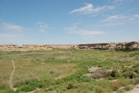
Finally, the fortress of Durnali in the Merv oasis should be mentioned (fig. 10/. It is located 25 km north of Giaur-kala amid the ruins of a Parthian city, where later a Seljuk town flourished. The fortress is nearly rectangular, the walls measuring 183, 173, 160, and 150 meters. The socle was built with pachsa (raw clay) and the walls, which still stand 7 to 8 meters high, are of brick. Square towers reinforce the walls, at 10 to 17 meter intervals.[11][11] The fortress is a typical example of Parthian fortification.
Balkan Daglary (Gora Ardan) is an 1880 meter peak in the western plains of Turkmenistan in Balkan Province. The town of Balkanabat lies on its foothills. Gora Ardan is an isolated mountain that stands about 2000 meters above the shore of the below-sea level Caspian Sea.
Inkább azt mondd meg, hogyan kerültek hozzánk olyan földrajzi nevek, mint a Barakšavagy a Badakhšan.
A szogd város nevének hazai Árpád-kori megfelelője a Barakcsa, az említett hegyvidéki területé (tádzsik nevén: Бадахшон...!) a Badacsony... Ja, és szóljál, ha valakinek a levédett cikkeiben ezeket az analógiákat megtalálod. Ha a sajátjaidban, akkor pláne.
„kivel, kikkel viaskodhatott Szent László? A kunokkal biztos, hogy nem, mert azok még meg sem születtek”
Toru Senga: „Az, hogy Kāšgarī 11. századi művében, amelyben egy szó sem esik a kimekekről, következetesen csak a Yimäk/Yämäk névalakot használja, nem mutat arra, hogy a jemek meg a kimekek azonos s egyenértékű, hanem szerintünk egyszerűen arról van szó, hogy Kāšgarī korában már nem létezett a kimekek törzsszövetsége – amelynek egykori területeit akkoriban a kipcsak (kun ~ komán ~ polovec) törzsszövetség uralta –, és Kāšgarī csupán annak egy volt tagjáról, a jemek törzsről ad hírt.”1
Mahmud ibn Hussayn ibn Muhammad al-Kashgari wrote the first comprehensive dictionary of Turkic languages, the Dīwān ul-Lughat al-Turk (Arabic: Collection of Turkic words) in 1072.
Vásáry István: „A 11. és 13. században, nagyjából az 1050 és 1220 közötti majdnem két évszázadban a különböző kun–kipcsak csoportok aktívan beleszóltak a környező, elsősorban az orosz, a bizánci és a kaukázusi területek politikai életébe. A kijevi Oroszország történetének szerves részét képezi a kunokkal való hol baráti, hol ellenséges kapcsolat. Fontos hangsúlyoznunk az elsőt is, mivel az egyes orosz részfejedelemségek gyakran használtak fel kun szövetséges csapatokat egymás közti harcaikban. A kun és orosz előkelők gyakran házassági kötelékkel erősítették meg politikai szövetségeiket. Egy helyi orosz–kun összecsapás emlékét őrzi a híres orosz Igor-ének a 12. század végéről.”
PVL: „В год 6569 (1061). Впервые пришли половцы войною на Русскую землю; Всеволод же вышел против них месяца февраля во 2-й день. И в битве победили Всеволода и, повоевав землю, ушли. То было первое зло от поганых и безбожных врагов. Был же князь их Искал.”
1Megjegyzések a kimekek törzsszövetségének kialakulásához; in: Antik Tanulmányok XLI/1–2 (1997), 185.
2 I. m. 157.
1. Kh. Atamuradov–O. Pereladova: Conserving Biodiversity of Central Asia, Turkmenistan; Ashgabat (Askhabad), 1997
2. Red Book of Turkmenistan; Ashgabat, 1999
Könnyen lehet egyébként, hogy Askhabadot a parthus dinasztiaalapítóról nevezték el, középperzsául ugyanis az ő neve Ašk volt, ehhez járult volna a 'város'-t jelentő ābād utótag. Más magyarázat szerint Askhabad 'a szerelem városa'.
The name is believed to derive from the Persian Ashk-ābād meaning "the City of Arsaces." Another explanation is that the name is a dialect version of the Arabic-derived Persian word of عشق (eshq meaning "love") and Persian آباد (ābād meaning "cultivated place" or "city", etymologically "abode"), and hence loosely translates as "the city of love."
Фрагмент согдийского щита с горы Муг. На его поверхности сохранилась великолепная роспись с изображением всадника в полном вооружении. Круглый щит (диаметром 61 см) собран из дощечек шириной около девяти сантиметров. Он слегка выгнут — его середина возвышается над краями на два сантиметра. По краю щита пропущена металлическая оковка, с обеих сторон он оклеен тонким пергаментом. С внутренней стороны металлическими заклепками прикреплена ручка с приделанной к ней ременной петлей — с ее помощью щит забрасывался за спину. VII—VIII вв. Средняя Азия. Санкт-Петербург. Эрмитаж.
Кыргызский тяжеловооруженный воин эпохи Великодержавия. Его защитное вооружение состоит из крупнопластинчатого клепаного шлема (а) с бармицей (б), изготовленной из металлических пластин и снабженной мягкой подкладкой; короткополого панциря (в), сплетенного шнурами из железных пластин; накладных деревянных щитков (г) на плечах и груди; также деревянных поножей (д) и наручей (е); щита (ж), собранного из обтянутых кожей дощечек. При атаке в конном строю или стрельбе из лука щит забрасывался за спину, где удерживался с помощью специального ремня (з). На воине — два пояса. К «стрелковому» поясу крепится берестяной колчан (и) открытого типа, украшенный накладными костяными пластинками (к). В руках у воина две сабли — с брусковидным (л) и ромбовидным (м) перекрестиями. Дополняет вооружение ближнего боя узколезвийный топор (н) со шпеньком на обухе. Реконструкция по материалам Ю. С. Худякова.
Óperzsa Suguda c. dolgozatában (Antik Tanulmányok XXII/1, 1975) Harmatta rámutat arra, hogy az óperzsa feliratokban a szogdok népneve legkorábban és leggyakrabban suguda alakban fordul elő. Ez a literáció élesen különbözik az említett etnikum nevének más forrásokból előbukkanó alakjától, tekintettel arra, hogy pl. az elámiak šu-ug-dának, a babiloniak su-ug-dunak, a hellének meg Σογδ-nak írták. A -gd- hangkapcsolat egyedül magában a szogdban oldódik még fel -gud-dá, így elképzelhető (bár Harmatta nem emellett foglal állást), hogy innen került át az ejtéskönnyítő u hanggal megtoldott alak a perzsába.
Mindenesetre a népnévnek Harmatta 'égetett, tiszta, szent' jelentését adja, ami szerinte a mágikus tűztisztelettel állhat összefüggésben, hiszen a perzsák (és nyilván a parthusok) hite szerint a tűznek purifikáló szerepe volt.
A kitűnő iranista végezetül egy Σουγδαία nevű várost említ a Krím-félszigetről, amely település nevének etimológiáját már Vasmer is egy hipotetikus alán kifejezéssel összefüggésben vizsgálta.
Felvetődik a kérdés, Szeged városunk nevének és a kelta-ibér Szegeda településnévnek vajon lehet-e kapcsolata Szogdiával és a szogdok népnevével.

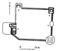 A manszúr-depei (manszúr-tepei) központi udvar (Nisza mellett)
 Kizil-kala
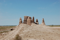
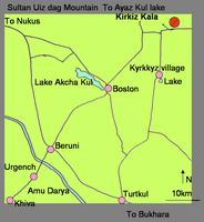 Kirkiz-kala

 Ajaz-kala
 Guldurszun-kala
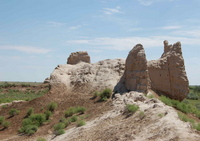
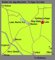 Koj-kala
 Toprak-kala
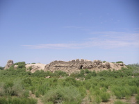
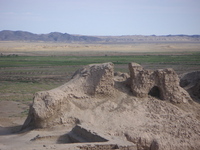
 Koj-krülgán-kala
 A Nagy-Balkán- és a Kis-Balkán-dombság a Kaszpi-tenger keleti partvidékén
 Az Amu-darja Természetvédelmi Körzet:
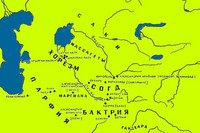 Parthia, Horezm, Szogdia, Baktria...
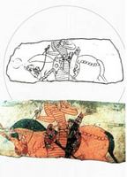 Фрагмент согдийского щита с горы Муг. На его поверхности сохранилась великолепная роспись с изображением всадника в полном вооружении. Круглый щит (диаметром 61 см) собран из дощечек шириной около девяти сантиметров. Он слегка выгнут — его середина возвышается над краями на два сантиметра. По краю щита пропущена металлическая оковка, с обеих сторон он оклеен тонким пергаментом. С внутренней стороны металлическими заклепками прикреплена ручка с приделанной к ней ременной петлей — с ее помощью щит забрасывался за спину. VII—VIII вв. Средняя Азия. Санкт-Петербург. Эрмитаж.
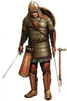
 Кыргызский тяжеловооруженный воин эпохи Великодержавия. Его защитное вооружение состоит из крупнопластинчатого клепаного шлема (а) с бармицей (б), изготовленной из металлических пластин и снабженной мягкой подкладкой; короткополого панциря (в), сплетенного шнурами из железных пластин; накладных деревянных щитков (г) на плечах и груди; также деревянных поножей (д) и наручей (е); щита (ж), собранного из обтянутых кожей дощечек. При атаке в конном строю или стрельбе из лука щит забрасывался за спину, где удерживался с помощью специального ремня (з). На воине — два пояса. К «стрелковому» поясу крепится берестяной колчан (и) открытого типа, украшенный накладными костяными пластинками (к). В руках у воина две сабли — с брусковидным (л) и ромбовидным (м) перекрестиями. Дополняет вооружение ближнего боя узколезвийный топор (н) со шпеньком на обухе. Реконструкция по материалам Ю. С. Худякова.
 1. Litván könnyűlovas a XI. századból
 Lent: keletrómai és szláv gyalogos küzdelme a VI–VII. századból
 1. Türk (török) páncélos lovag a VII–VIII. századból (jobbra)
 1. Szaka nehézpáncélos lovag a Kr. e. IV–III. századból
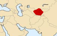 Szogdia, eredetileg feltehetően: Szuguda